IMAGES TAKEN NEAR TO
Upper Icknield Way, AYLESBURY, HP22 5LH
Introduction
This page details the photographs taken nearby to Upper Icknield Way, HP22 5LH by members of the Geograph project.
The Geograph project started in 2005 with the aim of publishing, organising and preserving representative images for every square kilometre of Great Britain, Ireland and the Isle of Man.

There are currently over 7.5m images from over14,400 individuals and you can help contribute to the project by visiting https://www.geograph.org.uk
Image Map
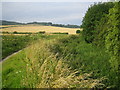
Images are licensed for reuse under creativecommons.org/licenses/by-sa/2.0
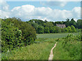
Notes
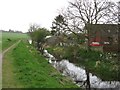
- Clicking on the map will re-center to the selected point.
- The higher the marker number, the further away the image location is from the centre of the postcode.
Image Listing (32 Images Found)
Images are licensed for reuse under creativecommons.org/licenses/by-sa/2.0
Image
Details
Distance
1
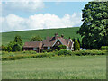
Lodge Farm from canal towpath
This is from the unnavigable part of the Grand Union Canal, Wendover Arm, currently only used as a water conduit with a lowered water level. It is down on the left.
Image: © Robin Webster
Taken: 5 Jun 2014
0.02 miles
2
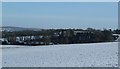
Lodge Farm surrounded by snow-covered fields
Lodge Farm between Tring and Bucklandwharf is seen surrounded by trees with snow covered fields in the foreground. Taken from near the highest point of Stable Bridge Road.
Image: © Rob Farrow
Taken: 26 Jan 2013
0.03 miles
3
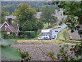
Upper Icknield Way near Buckland Wharf
Traffic on the B4009 Upper Icknield Way as viewed across the field from the old A41 at Buckland Wharf.
Image: © David Sands
Taken: 29 Sep 2007
0.10 miles
4
Lodge for Lodge Farm
On the Upper Icknield Way.
Image: © Robin Webster
Taken: 5 Jun 2014
0.10 miles
5
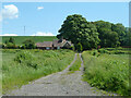
Track from canal to Upper Icknield Way and Lodge Farm
A curious track - was it here before the canal? The Buckland - Aston Clinton parish boundary follows it, and the boundary follows the same straight line on the other side of the canal, evident now as a noticeable property boundary through modern housing. Determining what came first would require study of pre 1799 documents, ideally maps, if they exist.
Image: © Robin Webster
Taken: 5 Jun 2014
0.11 miles
6
Wendover Arm: The Canal-side footpath west of Canal Bridge No 6
There are not many seats beside the canal-side footpath. This one provides a good view across the fields towards the Chiltern Escarpment. The woods in the distance here are known as Daniel's Hole.
See Image
Image: © Chris Reynolds
Taken: 9 Apr 2009
0.12 miles
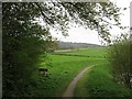
7
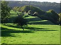
Terraced farmland at Lodge Farm
This is a close-up of the quite unusual stepped farmland near Lodge Farm. See Image] for a wider view of this lovely farmland.
Image: © Rob Farrow
Taken: 7 Oct 2006
0.12 miles
8
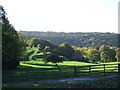
Near Lodge Farm
Lodge Farm is on Upper Icknied Way which runs from near Bucklandwharf to Halton and Wendover. I regularly drive along this road and always love this view across beautiful farmland with Wendover Woods rising in the background.
It looks wonderful in every season - perhaps at its best in a few weeks time as more of the greens turn to ochre, gold and red.
Image: © Rob Farrow
Taken: 7 Oct 2006
0.12 miles
9
Grand Union Canal (Wendover Arm) in Bucklandwharf
The disused canal is the reed-infested hollow down the bank to the right in this location. See Image for restoration work in progress by the Wendover Arm Trust http://www.wendoverarmtrust.co.uk/AboutUs/AboutUs.html about a kilometre away to the north-east.
Image: © Nigel Cox
Taken: 2 Aug 2007
0.14 miles
10
Wendover Arm: The Canal West of Bridge No 6
There are no new low bridges from here to Halton Village – so once the canal has been re-opened to Buckland Wharf, and the two bridges there (No 5B & No 6) are raised navigation should be possible to Halton.
See Image
Image: © Chris Reynolds
Taken: 9 Apr 2009
0.15 miles