IMAGES TAKEN NEAR TO
Manor Road, AYLESBURY, HP22 4HW
Introduction
This page details the photographs taken nearby to Manor Road, HP22 4HW by members of the Geograph project.
The Geograph project started in 2005 with the aim of publishing, organising and preserving representative images for every square kilometre of Great Britain, Ireland and the Isle of Man.

There are currently over 7.5m images from over14,400 individuals and you can help contribute to the project by visiting https://www.geograph.org.uk
Image Map
Images are licensed for reuse under creativecommons.org/licenses/by-sa/2.0
Notes
- Clicking on the map will re-center to the selected point.
- The higher the marker number, the further away the image location is from the centre of the postcode.
Image Listing (37 Images Found)
Images are licensed for reuse under creativecommons.org/licenses/by-sa/2.0
Image
Details
Distance
1
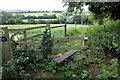
Grass covered road junction
At a minor road junction on Church Lane.
Image: © Michael Trolove
Taken: 30 Dec 2012
0.03 miles
2
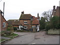
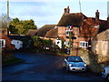
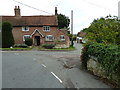
The Black Boy, Oving
Oving's pub. "The Black Boy was built circa 1524. The original building is still standing. The front door, bar area with beams, kitchen and living accommodation can still be seen. Various extensions and outbuildings were added in the 20th Century. The Hossle or village pond, situated at the bottom of the pub gardens, was the only source of clean running spring water in the area during drought. Farmers with sheep, cattle or horses would walk their animals from miles away to the spring, which is still as abundant today. It is rumoured that Oliver Cromwell and his New Model Army camped in the pub garden and hossle after sacking nearby Bolebec Castle at Whitchurch.
The most common [explanation for the name] is from when Charles II (1660-1685) was in exile his dark complexion earned him the nickname The Black Boy." http://theblackboyoving.co.uk/about/
Image: © HelenK
Taken: 27 Dec 2011
0.06 miles
4
The Black Boy, Oving
Village pub with a long history including a reputed visit by Cromwell http://www.theblackboyoving.com/
Image: © Michael Trolove
Taken: 30 Dec 2012
0.07 miles
5
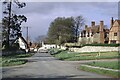
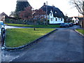
Oving village
Looking towards the centre of the village . The church is hidden, but can just be made out behind the trunk of the lone, bare tree. This is Church Lane, which continues sharply to the right in front of the house painted white and the church.
Image: © David Purchase
Taken: 24 Apr 1966
0.08 miles
6
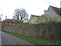
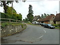
Dark Lane, with Oving House
This lane runs past Oving House and its associated outbuildings.
Image: © HelenK
Taken: 27 Dec 2011
0.08 miles
9
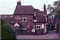
The Black Boy, Oving
Oving's village pub was built in the 16th century although there are 20th century extensions. It is noted for its beer garden and views over the Buckinghamshire countryside. The Black Boy name is of obscure origin and there are a number of 'Black Boy' pubs around the country; one possibility is that it refers to colliers, although that would seem unlikely here. Perhaps a more likely possibility is a reference to Charles II who is said to have had a dark complexion during his years of exile. There is a connection with that period of English history; Oliver Cromwell and his New Model Army are believed to have camped by the pub after sacking nearby Bolebec Castle.
Image: © Stephen McKay
Taken: Unknown
0.09 miles