IMAGES TAKEN NEAR TO
Smiths Lane, AYLESBURY, HP18 9XF
Introduction
This page details the photographs taken nearby to Smiths Lane, HP18 9XF by members of the Geograph project.
The Geograph project started in 2005 with the aim of publishing, organising and preserving representative images for every square kilometre of Great Britain, Ireland and the Isle of Man.

There are currently over 7.5m images from over14,400 individuals and you can help contribute to the project by visiting https://www.geograph.org.uk
Image Map
Images are licensed for reuse under creativecommons.org/licenses/by-sa/2.0
Notes
- Clicking on the map will re-center to the selected point.
- The higher the marker number, the further away the image location is from the centre of the postcode.
Image Listing (6 Images Found)
Images are licensed for reuse under creativecommons.org/licenses/by-sa/2.0
Image
Details
Distance
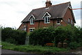
2
Entrance to Commonleys Farm
Cream teas served here.
Image: © Jackie Harman
Taken: 24 Aug 2006
0.11 miles
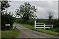
3
Smith's Lane, Waterperry Common
Part of a through route of sorts to Waterperry village, except just beyond here the status downgrades to "Other Route With Public Access" and the surface becomes full of potholes.
Image: © Des Blenkinsopp
Taken: 22 Oct 2018
0.12 miles
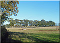
4
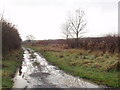
"Other route with public access" by Commonleys Farm
This ORPA leads from Waterperry Common, around via Drunkard's Corner to Waterperry. I guess it is a track where vehicle access is legal but discouraged - but a check with the highways authority would be needed to confirm that. There are no signs about its status on the track.
Image: © David Hawgood
Taken: 28 Nov 2008
0.21 miles
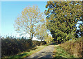
5
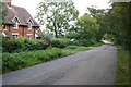
Road to Worminghall
Road to Worminghall at the cottage of Wood Farm
Image: © Shaun Ferguson
Taken: 7 Oct 2007
0.24 miles