IMAGES TAKEN NEAR TO
Brill, AYLESBURY, HP18 9XD
Introduction
This page details the photographs taken nearby to HP18 9XD by members of the Geograph project.
The Geograph project started in 2005 with the aim of publishing, organising and preserving representative images for every square kilometre of Great Britain, Ireland and the Isle of Man.

There are currently over 7.5m images from over14,400 individuals and you can help contribute to the project by visiting https://www.geograph.org.uk
Image Map (Loading...)


Getting Data...Please wait
Leaflet Map data © OpenStreetMap
Images are licensed for reuse under creativecommons.org/licenses/by-sa/2.0
Notes
- Clicking on the map will re-center to the selected point.
- The higher the marker number, the further away the image location is from the centre of the postcode.
Image Listing (7 Images Found)
Images are licensed for reuse under creativecommons.org/licenses/by-sa/2.0
Image
Details
Distance
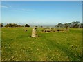
1
Muswell Hill
Footpath up to Muswell Hill
Image: © Shaun Ferguson
Taken: 21 Feb 2009
0.15 miles
2
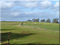
Sheep on Muswell Hill
The summit with trig. point (197 m) and seats is at the extreme left.
Image: © Robin Webster
Taken: 22 Feb 2014
0.18 miles
3
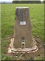
Muswell Hill Trig Point
Showing OS Flush Bracket S1460
Image: © Chris Cursley
Taken: 9 May 2010
0.18 miles
4
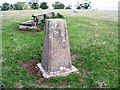
Trig Point 0728 on Muswell Hill
Great views further north along the footpath
Image: © Damon Knight
Taken: 28 Aug 2006
0.18 miles
5
Muswell Hill
Parked just passed entry to Muswell Hill Manor, through gate to trig next to cross country jumps. Super views on lovely morning and my completion of 11 HuMPs in 24 hours from 10:20 on 05/03/12 to 10:15 06/03/12.
Name: Muswell Hill
Hill number: 5397
Height: 198m / 650ft
Area: 39: Central and Eastern England
Class: Hu
Grid ref: SP 64127 15309
Summit feature: ground 7m NW of trig point
Drop: 126m
Col: 72m SP693154
Image: © Rude Health
Taken: 6 Mar 2012
0.19 miles
6
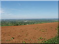
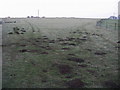
Shotover iron sand field, Muswell Hill, near Brill
At Brill and the top of Muswell Hill there are small areas of red soil, the same as at Shotover near Oxford. This is a cretaceous greensand; lower land around is older clay.
Image: © David Hawgood
Taken: 3 Jun 2006
0.24 miles
7
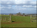
Gateway and field, Muswell Hill
Looking towards Muswell Hill Farm.
Image: © Robin Webster
Taken: 22 Feb 2014
0.24 miles