IMAGES TAKEN NEAR TO
Badgers Rise, AYLESBURY, HP17 8RR
Introduction
This page details the photographs taken nearby to Badgers Rise, HP17 8RR by members of the Geograph project.
The Geograph project started in 2005 with the aim of publishing, organising and preserving representative images for every square kilometre of Great Britain, Ireland and the Isle of Man.

There are currently over 7.5m images from over14,400 individuals and you can help contribute to the project by visiting https://www.geograph.org.uk
Image Map
Images are licensed for reuse under creativecommons.org/licenses/by-sa/2.0
Notes
- Clicking on the map will re-center to the selected point.
- The higher the marker number, the further away the image location is from the centre of the postcode.
Image Listing (53 Images Found)
Images are licensed for reuse under creativecommons.org/licenses/by-sa/2.0
Image
Details
Distance
1
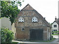
Dovecots on a gable-end in Stone
Image: © Sarah Charlesworth
Taken: 25 May 2011
0.04 miles
3
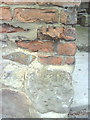
Benchmark on #62 Oxford Road
Ordnance Survey cut mark benchmark described on the Bench Mark Database at http://www.bench-marks.org.uk/bm35859
Image: © Roger Templeman
Taken: 29 Oct 2010
0.06 miles
4
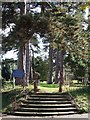
Steps to St. John the Baptist, Stone
The church of St.John the Baptist in Stone south of Aylesbury, is set in a beautiful churchyard. These curved steps lead up to a grass pathway between towering pines through the churchyard.
Image: © Rob Farrow
Taken: 24 Sep 2006
0.07 miles
5
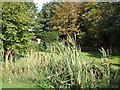
Village Pond, Stone
Opposite Image] is this duckweed covered pond with reed-mace (often incorrectly referred to as bulrushes) much in evidence in the foreground. The pond lies in the angle created between the Bishopstone and Oxford Roads.
Image: © Rob Farrow
Taken: 24 Sep 2006
0.07 miles
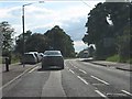
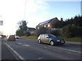
7
Stone - Bishopstone Road crossroads
Taken from the westbound A418 on one of very few sunny days in June 2012 - one of the wettest months recorded in the UK.
Image: © Peter Whatley
Taken: 19 Jun 2012
0.08 miles
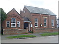
8
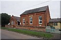
The Methodist Chapel
The meeting place for Stone Methodist Church.
Image: © Bill Boaden
Taken: 23 Oct 2023
0.08 miles
9
Stone Methodist Church, Bucks
Situated in Eythrope Road, this Wesleyan Chapel dates from 1877, and is one of eighteen churches in the Vale of Aylesbury Methodist Circuit. Services are held here at 11.00am each Sunday whilst Open Fellowship takes place here on the 4th Tuesday of the month at 2.30pm. The postcode of this Chapel is HP17 8PG.
Image: © David Hillas
Taken: 11 Apr 2012
0.08 miles
10
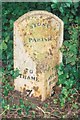
Old Milepost by the A418 in Stone
Cast iron post by the A418, in parish of Stone with Bishopstone and Hartwell (Aylesbury Vale District), Oxford Road; Stone village, opposite No. 82, just East of The Glebe, between cycle path and wooden domestic fence, near large road sign, on South side of road. Seymour iron casting, erected by the Aylesbury, Thame, Oxford & Shillingford turnpike trust in the 19th century.
Inscription reads:-
: TO / THAME / 7 / (MILES) : : STONE / PARISH : : TO / AYLES- / -BURY / 3 / (MILES) :
Maker:-
: SEYMOUR / AYLESBURY. :
Buckinghamshire HER.
HER Number: 1358600000 https://www.heritagegateway.org.uk/Gateway/Results_Single.aspx?uid=MBC25741&resourceID=1024
Milestone Society National ID: BU_AYTH03
Image: © A Rosevear & J Higgins
Taken: 15 Sep 2002
0.09 miles