Old Milepost by the A418 in Stone
Introduction
The photograph on this page of Old Milepost by the A418 in Stone by A Rosevear & J Higgins as part of the Geograph project.
The Geograph project started in 2005 with the aim of publishing, organising and preserving representative images for every square kilometre of Great Britain, Ireland and the Isle of Man.

There are currently over 7.5m images from over 14,400 individuals and you can help contribute to the project by visiting https://www.geograph.org.uk
Old Milepost by the A418 in Stone
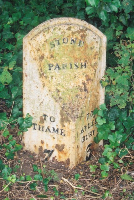
Image: © A Rosevear & J Higgins Taken: 15 Sep 2002
Cast iron post by the A418, in parish of Stone with Bishopstone and Hartwell (Aylesbury Vale District), Oxford Road; Stone village, opposite No. 82, just East of The Glebe, between cycle path and wooden domestic fence, near large road sign, on South side of road. Seymour iron casting, erected by the Aylesbury, Thame, Oxford & Shillingford turnpike trust in the 19th century. Inscription reads:- : TO / THAME / 7 / (MILES) : : STONE / PARISH : : TO / AYLES- / -BURY / 3 / (MILES) : Maker:- : SEYMOUR / AYLESBURY. : Buckinghamshire HER. HER Number: 1358600000 https://www.heritagegateway.org.uk/Gateway/Results_Single.aspx?uid=MBC25741&resourceID=1024 Milestone Society National ID: BU_AYTH03
Images are licensed for reuse under creativecommons.org/licenses/by-sa/2.0
Image Location
Latitude
51.803467
Longitude
-0.868901