IMAGES TAKEN NEAR TO
Sprigs Holly Lane, HIGH WYCOMBE, HP14 4DZ
Introduction
This page details the photographs taken nearby to Sprigs Holly Lane, HP14 4DZ by members of the Geograph project.
The Geograph project started in 2005 with the aim of publishing, organising and preserving representative images for every square kilometre of Great Britain, Ireland and the Isle of Man.

There are currently over 7.5m images from over14,400 individuals and you can help contribute to the project by visiting https://www.geograph.org.uk
Image Map (Loading...)


Getting Data...Please wait
Leaflet Map data © OpenStreetMap
Images are licensed for reuse under creativecommons.org/licenses/by-sa/2.0
Notes
- Clicking on the map will re-center to the selected point.
- The higher the marker number, the further away the image location is from the centre of the postcode.
Image Listing (15 Images Found)
Images are licensed for reuse under creativecommons.org/licenses/by-sa/2.0
Image
Details
Distance
1
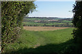
Footpath leaving Andridge
Part of the Chiltern Way. The church on West Wycombe Hill can be seen from here.
Image: © Bill Boaden
Taken: 20 Apr 2018
0.07 miles
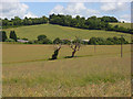
2
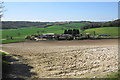
Hillside above Grange Farm Road
The valley has mixed farming, with some sheep at the bottom. Stokenchurch is on the far hill though you cannot see it.
Image: © Bill Boaden
Taken: 20 Apr 2018
0.12 miles
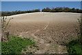
3
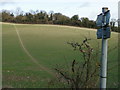
Path up a sloping field off Grange Park Road
Image: © Peter S
Taken: 28 Dec 2011
0.13 miles
4
View above Bennett End
Taken in a field full of barley below Andridge Farm, this view is looking south east towards The City and the surrounding Chiltern Hills.
Image: © David Hillas
Taken: 30 Jul 2016
0.16 miles
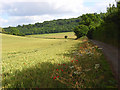
5
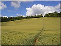
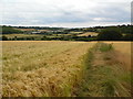
Footpath through wheat, Radnage
The Chiltern Way climbing the hillside from Grange Farm Road.
Image: © Andrew Smith
Taken: 5 Jul 2008
0.16 miles
6
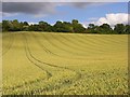
Wheat, Radnage
The hillside rising to the east of Grange Farm Road.
Image: © Andrew Smith
Taken: 5 Jul 2008
0.19 miles
7
Farmland, Stokenchurch
The dead trees are on Collier's Lane (bridleway) which has oil-seed rape to either side. Beyond are farm buildings on Grange Farm Road and a field of wheat with a footpath (the Chiltern Way) climbing up through it.
Image: © Andrew Smith
Taken: 5 Jul 2008
0.22 miles
8
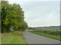
Sprigs Holly Lane
Looking west towards Radnage.
Image: © Robin Webster
Taken: 18 Oct 2015
0.22 miles
9
Footpath up to Andridge
This is a short but significant climb on the Chiltern Way. Andridge is at the top of the hill.
Image: © Bill Boaden
Taken: 20 Apr 2018
0.22 miles
10
Farmland, Radnage
A field of wheat alongside Grange Farm Road.
Image: © Andrew Smith
Taken: 5 Jul 2008
0.23 miles