IMAGES TAKEN NEAR TO
Cadmore End, HIGH WYCOMBE, HP14 3PL
Introduction
This page details the photographs taken nearby to HP14 3PL by members of the Geograph project.
The Geograph project started in 2005 with the aim of publishing, organising and preserving representative images for every square kilometre of Great Britain, Ireland and the Isle of Man.

There are currently over 7.5m images from over14,400 individuals and you can help contribute to the project by visiting https://www.geograph.org.uk
Image Map
Images are licensed for reuse under creativecommons.org/licenses/by-sa/2.0
Notes
- Clicking on the map will re-center to the selected point.
- The higher the marker number, the further away the image location is from the centre of the postcode.
Image Listing (33 Images Found)
Images are licensed for reuse under creativecommons.org/licenses/by-sa/2.0
Image
Details
Distance
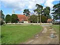
1
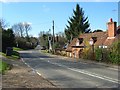
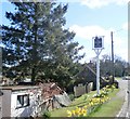
The B482, Cadmore End
The western end of the village, most of which is slightly off the main road. The second, mostly hidden building is the Old Ship pub.
Image: © Andrew Smith
Taken: 27 Mar 2008
0.08 miles
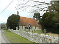
3
Cadmore End Church
St Mary le Moor Cadmore End Church
Image: © Shaun Ferguson
Taken: 7 Mar 2008
0.10 miles
4
Roadside at The Old Ship Pub - Cadmore End
Image: © Anthony Parkes
Taken: 9 Apr 2016
0.10 miles
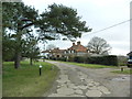
5
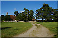
Approaching St Mary le Moor, Cadmore End
The track from Hanger Wood leads into Cadmore End opposite St Mary le Moor Church
Image: © Rob Rogers
Taken: 12 Sep 2009
0.10 miles
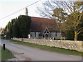
6
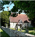
Cadmore End church
This small church is dedicated to St Mary le Moor. It is Victorian, built in 1851. It has no tower but just a small bell structure on the western end.
Image: © Graham Horn
Taken: 8 May 2011
0.11 miles
7
Cadmore End church
This small church is dedicated to St Mary le Moor. It is Victorian, built in 1851. It has no tower but just a small bell structure on the western end.
Image: © Graham Horn
Taken: 8 May 2011
0.11 miles
8
The church, Cadmore End
Built in 1851 and dedicated to the somewhat obscure St Mary-le-Moor. The track is the bridleway entering the western end of the village.
Image: © Andrew Smith
Taken: 27 Mar 2008
0.11 miles
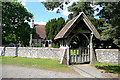
9
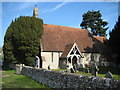
Cadmore End: The Church of St Mary le Moor
Built in 1851 the church is a Grade II Listed Building and the English Heritage Listed Buildings website describes it thus:-
"Parish church. 1851. By Rhode Hawkins. Flint with stone dressings, tiled roofs, stone coped gables. Nave, S. porch, chancel, small N. vestry. Off-set buttresses. W. end of nave has arched bellcote corbelled out over 2 small trefoil arches, and 2 lancet windows. 3 lancets to N. side of nave; 2 lancets and a 2-light window with plate tracery to S. Chamfered S. door in timber-framed porch. Chancel has 2-light plate-traceried window and lean-to, formerly porch, to S., triple lancets with taller central light at E. end, and gabled vestry to N. Simple interior with large double-chamfered chancel arch; contemporary fittings and glass."
In understanding this the main façade visible here is the southern one with the west end bellcote visible over the top of the yew tree.
Image: © Nigel Cox
Taken: 19 Mar 2011
0.12 miles