IMAGES TAKEN NEAR TO
Clinkard Place, Church Road, HIGH WYCOMBE, HP14 3HQ
Introduction
This page details the photographs taken nearby to Clinkard Place, Church Road, HP14 3HQ by members of the Geograph project.
The Geograph project started in 2005 with the aim of publishing, organising and preserving representative images for every square kilometre of Great Britain, Ireland and the Isle of Man.

There are currently over 7.5m images from over14,400 individuals and you can help contribute to the project by visiting https://www.geograph.org.uk
Image Map (Loading...)


Getting Data...Please wait
Leaflet Map data © OpenStreetMap
Images are licensed for reuse under creativecommons.org/licenses/by-sa/2.0
Notes
- Clicking on the map will re-center to the selected point.
- The higher the marker number, the further away the image location is from the centre of the postcode.
Image Listing (6 Images Found)
Images are licensed for reuse under creativecommons.org/licenses/by-sa/2.0
Image
Details
Distance
1
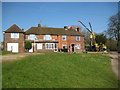
Ditchfield: The former Jolly Blacksmith public house
The right end building of this terrace of houses used to be the Jolly Blacksmith public house but is now a private residence. Despite this a large Whitbread sign is still in place on the flank wall round the corner and the very faded pub sign is also still in place in front of the cranes.
The 1877 Ordnance Survey map shows the terrace, but only by the 1898 edition does the annotation P.H. appear with a Smithy behind.
Image: © Nigel Cox
Taken: 19 Mar 2011
0.16 miles
2
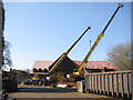
Ditchfield: E&R Meakes Forge Works
The Ordnance Survey map of 1898 shows that a Smithy was in operation at this location at that time, serving the needs of the agricultural community, and the business is evidently still thriving today. This photograph was taken from the public footpath across Ditchfield Common.
Image: © Nigel Cox
Taken: 19 Mar 2011
0.18 miles
3
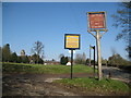
Lane End: Signs
There are a couple of fine signs here, advertising the presence of
Image
Image
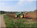
across Ditchfield Common to the left.
Image
is visible to the left.
Church Road is to the right.
Image: © Nigel Cox
Taken: 19 Mar 2011
0.20 miles
4
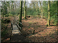
Footbridge in the woods
The path through Fining Wood crosses a small stream.
Image: © Des Blenkinsopp
Taken: 9 Apr 2015
0.21 miles
6
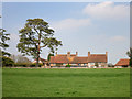
Moor Farm
I suppose I could have gone closer to get more of the building, but I quite like this shot from a distance.
Image: © Des Blenkinsopp
Taken: 9 Apr 2015
0.22 miles