IMAGES TAKEN NEAR TO
Station Close, HIGH WYCOMBE, HP13 6LF
Introduction
This page details the photographs taken nearby to Station Close, HP13 6LF by members of the Geograph project.
The Geograph project started in 2005 with the aim of publishing, organising and preserving representative images for every square kilometre of Great Britain, Ireland and the Isle of Man.

There are currently over 7.5m images from over14,400 individuals and you can help contribute to the project by visiting https://www.geograph.org.uk
Image Map
Images are licensed for reuse under creativecommons.org/licenses/by-sa/2.0
Notes
- Clicking on the map will re-center to the selected point.
- The higher the marker number, the further away the image location is from the centre of the postcode.
Image Listing (488 Images Found)
Images are licensed for reuse under creativecommons.org/licenses/by-sa/2.0
Image
Details
Distance
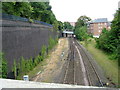
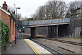
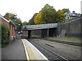
1
Approaching Wycombe station
The bridge in the middle distance carries the road known as Amersham Hill, the station is just after this bridge. View taken from a footbridge off Priory Avenue.
Image: © Mr Ignavy
Taken: 31 Dec 2008
0.01 miles
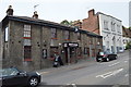
2
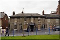
The Bootlegger
Grade II listed. http://www.britishlistedbuildings.co.uk/101125206-the-flint-cottage-inn-wycombe
Image: © N Chadwick
Taken: 25 Feb 2017
0.01 miles
3
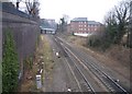
View from footbridge towards the railway station
The railway is cut into the hillside with wall on the left, I understand to be one of the largest retaining walls in Europe.
Image: © Peter Jemmett
Taken: 12 Aug 2007
0.02 miles
4
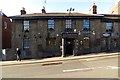
The Alehouse and Bottle Bar on Amersham Hill
Image: © Steve Daniels
Taken: 3 Nov 2013
0.02 miles
6
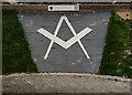
Freemasons' Garden
Located beside High Wycombe railway station, the garden was created in 2013 and is maintained by members from 21 lodges. The Freemason symbol is flanked by grass banks and flower beds.
Image: © Peter Trimming
Taken: 23 Mar 2016
0.03 miles
7
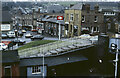
Amersham Hill, High Wycombe
This is the view from Totteridge Road across the western end of High Wycombe station to Amersham Hill as it was in 1983. There is a fine selection of period vehicles. 'Debug Computers' must have been ahead of its time - the market for home computers was only just beginning to take off.
Image: © Stephen McKay
Taken: Unknown
0.03 miles
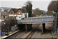
9
Bridge over railway west of High Wycombe station
The bridge carries Crendon Street, part of the A404.
Image: © Richard Vince
Taken: 23 Sep 2017
0.03 miles
10
Bridge at High Wycombe
Carrying the A404 across the railway line.
Image: © Peter Trimming
Taken: 23 Mar 2016
0.03 miles