IMAGES TAKEN NEAR TO
The Acres, HIGH WYCOMBE, HP13 5NR
Introduction
This page details the photographs taken nearby to The Acres, HP13 5NR by members of the Geograph project.
The Geograph project started in 2005 with the aim of publishing, organising and preserving representative images for every square kilometre of Great Britain, Ireland and the Isle of Man.

There are currently over 7.5m images from over14,400 individuals and you can help contribute to the project by visiting https://www.geograph.org.uk
Image Map
Images are licensed for reuse under creativecommons.org/licenses/by-sa/2.0
Notes
- Clicking on the map will re-center to the selected point.
- The higher the marker number, the further away the image location is from the centre of the postcode.
Image Listing (23 Images Found)
Images are licensed for reuse under creativecommons.org/licenses/by-sa/2.0
Image
Details
Distance
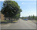
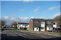
1
Middlebrook Way
Middlebrook Way heading up to Pastures Free Methodist Church Downley
Image: © Shaun Ferguson
Taken: 25 Feb 2008
0.06 miles
2
The Pastures west of the Disraeli School
Image: © Stuart Logan
Taken: 30 Jul 2014
0.07 miles
3
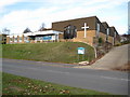
High Wycombe: The Pastures Church
The church dates from 1970 when it was built to serve the new housing estates on the north side of Wycombe. It is on the road called The Pastures hence the name. The church's website is here http://www.thepastures.org.uk/ Curiously it does not merit the + symbol of a church on the current Ordnance Survey 1:50,000 scale mapping although it is correctly shown on the larger scale 1:25,000 series. It is visible at the top of the hill in Shaun's Image
Image: © Nigel Cox
Taken: 7 Nov 2009
0.07 miles
4
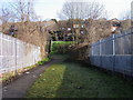
Footpath over the railways bridge
Footpath over the railway bridge up to Cotswold Way.
Image: © Shaun Ferguson
Taken: 25 Feb 2008
0.16 miles
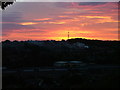
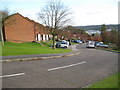
6
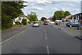
Hithercroft Road, High Wycombe
On top of a ridge overlooking the Wye valley, these northern suburbs are a bit of a climb from the town centre.
Image: © Des Blenkinsopp
Taken: 25 Jan 2018
0.18 miles
7
High Wycombe: Mendip Way
The staggered arrays of houses running up and down the hillsides on Mendip Way and its parallel roads, Cumbrian, Brecon and Cotswold Ways appear just as amorphous orange infills on the Ordnance Survey 1:50,000 scale map, but look at the larger scale 1:25,000 scale maps and they appear as a series of wriggly worms! Practically this is an interesting modern alternative to the stepped housing terraces that used to be built on steep hillsides.
Image: © Nigel Cox
Taken: 7 Nov 2009
0.18 miles