IMAGES TAKEN NEAR TO
London Road, HEMEL HEMPSTEAD, HP1 2RU
Introduction
This page details the photographs taken nearby to London Road, HP1 2RU by members of the Geograph project.
The Geograph project started in 2005 with the aim of publishing, organising and preserving representative images for every square kilometre of Great Britain, Ireland and the Isle of Man.

There are currently over 7.5m images from over14,400 individuals and you can help contribute to the project by visiting https://www.geograph.org.uk
Image Map (Loading...)


Getting Data...Please wait
Leaflet Map data © OpenStreetMap
Images are licensed for reuse under creativecommons.org/licenses/by-sa/2.0
Notes
- Clicking on the map will re-center to the selected point.
- The higher the marker number, the further away the image location is from the centre of the postcode.
Image Listing (34 Images Found)
Images are licensed for reuse under creativecommons.org/licenses/by-sa/2.0
Image
Details
Distance
1
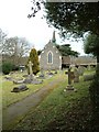
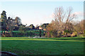
St. John the Evangelist church & churchyard
Image: © Edward Farrow
Taken: 11 Mar 2006
0.04 miles
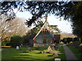
2
St. John the Evangelist, Bourne End
This is a view of the side of this little church.
Image: © Edward Farrow
Taken: 11 Mar 2006
0.04 miles
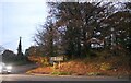
3
St John the Evangelist, Bourne End
Completed in 1855 and designed by George Gilbert Scott. The new extension was completed in 2007.
Image: © Bikeboy
Taken: 8 Mar 2014
0.06 miles
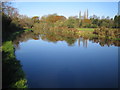
5
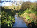
River Bulbourne in Bourne End
The Grand Union Canal was built along the valley of the River Bulbourne from Hemel Hempstead to Tring, paralleling it for much of the way. This is the shallow and clear Bulbourne photographed a couple of metres off the canal towpath which is to the right.
Image: © Nigel Cox
Taken: 15 Nov 2007
0.06 miles
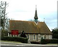
6
St John The Evangelist Church
Viewed from Sharpes Lane.
Image: © Tom Presland
Taken: 15 Nov 2010
0.07 miles
9
Grand Union Canal near Bourne End
This comparatively broad reach of the Grand Union Canal was completed in 1799 as part of the Grand Junction Canal.
Image: © Nigel Cox
Taken: 15 Nov 2007
0.11 miles
10
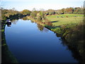
Grand Union Canal in Bourne End
Viewed from the Sharpes Lane bridge, the canal is comparatively wide along this reach. Horses are grazing in the field to the right which is markedly lower than the water level in the canal.
Image: © Nigel Cox
Taken: 15 Nov 2007
0.11 miles