IMAGES TAKEN NEAR TO
Whincup Close, HIGH WYCOMBE, HP11 1TD
Introduction
This page details the photographs taken nearby to Whincup Close, HP11 1TD by members of the Geograph project.
The Geograph project started in 2005 with the aim of publishing, organising and preserving representative images for every square kilometre of Great Britain, Ireland and the Isle of Man.

There are currently over 7.5m images from over14,400 individuals and you can help contribute to the project by visiting https://www.geograph.org.uk
Image Map (Loading...)


Getting Data...Please wait
Leaflet Map data © OpenStreetMap
Images are licensed for reuse under creativecommons.org/licenses/by-sa/2.0
Notes
- Clicking on the map will re-center to the selected point.
- The higher the marker number, the further away the image location is from the centre of the postcode.
Image Listing (20 Images Found)
Images are licensed for reuse under creativecommons.org/licenses/by-sa/2.0
Image
Details
Distance
1
Lancaster Road
Lancaster Road on Cressex Industrial Estate heading down to Desborough Avenue
Image: © Shaun Ferguson
Taken: 7 Mar 2008
0.08 miles
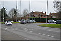
2
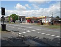
High Wycombe: Shell Cressex filling station
The garage is on Marlow Road at its junction with Desborough Avenue. At the time the photograph was taken petrol was 114.9 pence and diesel 113.9 pence per litre, the first time that the latter had been cheaper than the former for many years. The traffic lights are part-time signals.
Image: © Nigel Cox
Taken: 25 Jul 2015
0.08 miles
3
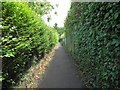
High Wycombe: Footpath between Marlow Road and Shelley Road
The hilly ground south of High Wycombe was criss-crossed with several public footpaths long before the houses, schools and factories arrived. However when they were built the old footpath routes were kept and this is one running between Marlow Road and Shelley Road, at the start of the long straight section just down from Marlow Road.
Image: © Nigel Cox
Taken: 25 Jul 2015
0.13 miles
4
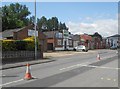
High Wycombe: Early industrial units on Lancaster Road
These six small industrial units were probably the earliest buildings on the Cressex Industrial Estate, now the Cressex Business Park. The 1938 Edition of the large scale Ordnance Survey map does not show them but the 1960 version certainly does, dating them probably to the 1950s.
The cones in the centre of the road were demarcating temporary one-way traffic workings while an underground service was being laid, as evidenced by the new trench scar in the foreground, when the photograph was taken.
Image: © Nigel Cox
Taken: 25 Jul 2015
0.14 miles
6
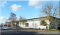
The Merlin Centre
The vaguely mystical name for this warehouse on the Cressex Industrial Estate.
To Let at the time of this picture.
Image: © Des Blenkinsopp
Taken: 4 Feb 2017
0.17 miles
7
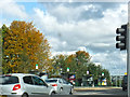
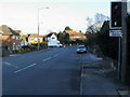
High Wycombe : Marlow Hill
Heading into the town on Marlow Hill.
Image: © Lewis Clarke
Taken: 9 Oct 2016
0.17 miles
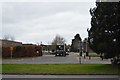
9
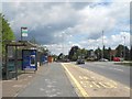
High Wycombe: Marlow Hill bus stops
These are mostly schools bus stops, but one public route, Purple 36, goes down Marlow Hill from here to High Wycombe town centre.
Image: © Nigel Cox
Taken: 25 Jul 2015
0.18 miles
10
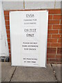
Notice at the back of the new Practical Driving Test Centre
This photo shows a notice propped against the back of the new practical driving test centre at Cliveden Office Village in Lancaster Road. It has the following wording:
DVSA
PARKING FOR
CUSTOMERS
ON TEST
ONLY
PLEASE DO NOT
PARK ANYWHERE
ELSE ON SITE
NO PRACTICING
AT ANY TIME
This is where candidates have to park their cars for their driving tests.
Update: this driving test centre closed on Friday 29th April 2022.
Image: © David Hillas
Taken: 10 Jun 2021
0.18 miles