IMAGES TAKEN NEAR TO
Whitehouse Lane, HIGH WYCOMBE, HP10 0NS
Introduction
This page details the photographs taken nearby to Whitehouse Lane, HP10 0NS by members of the Geograph project.
The Geograph project started in 2005 with the aim of publishing, organising and preserving representative images for every square kilometre of Great Britain, Ireland and the Isle of Man.

There are currently over 7.5m images from over14,400 individuals and you can help contribute to the project by visiting https://www.geograph.org.uk
Image Map
Images are licensed for reuse under creativecommons.org/licenses/by-sa/2.0
Notes
- Clicking on the map will re-center to the selected point.
- The higher the marker number, the further away the image location is from the centre of the postcode.
Image Listing (6 Images Found)
Images are licensed for reuse under creativecommons.org/licenses/by-sa/2.0
Image
Details
Distance
1
Holtspur Bottom
Taken from a nature reserve owned by Beaconsfield Town Council, looking towards the woods next to the A40.
Image: © Andrew Smith
Taken: 8 Apr 2006
0.18 miles
2
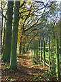
Footpath in woodland, Wooburn Moor
This is just south of the railway. The path crosses above the entrance to a short (about 0.25 km) tunnel which is passed unnoticed.
Image: © Andrew Smith
Taken: 9 Nov 2008
0.22 miles
3
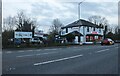
Rickshaw restaurant on London Road, Loudwater
It replaced the Bombay Grill Indian a few months ago.
Image: © David Howard
Taken: 17 Feb 2022
0.23 miles
4
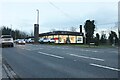
Hyundai garage on London Road, Loudwater
Image: © David Howard
Taken: 17 Feb 2022
0.23 miles
5
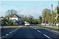
A40 London Road towards High Wycombe
La Limor bar and restaurant on the left.
Image: © Robin Webster
Taken: 8 Dec 2019
0.23 miles
6
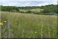
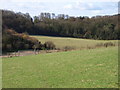
Meadow near Riding Farm
We stopped here on our walk, had a cup of tea and admired the view. Despite the map showing 'sewage works' it is not noticeable.
Image: © Graham Horn
Taken: 29 Aug 2011
0.23 miles