IMAGES TAKEN NEAR TO
Regency Place, RIPON, HG4 5FD
Introduction
This page details the photographs taken nearby to Regency Place, HG4 5FD by members of the Geograph project.
The Geograph project started in 2005 with the aim of publishing, organising and preserving representative images for every square kilometre of Great Britain, Ireland and the Isle of Man.

There are currently over 7.5m images from over14,400 individuals and you can help contribute to the project by visiting https://www.geograph.org.uk
Image Map (162 Images)


Getting Data...Please wait
Leaflet Map data © OpenStreetMap
Images are licensed for reuse under creativecommons.org/licenses/by-sa/2.0
Notes
- Clicking on the map will re-center to the selected point.
- The higher the marker number, the further away the image location is from the centre of the postcode.
Image Listing (162 Images Found)
Images are licensed for reuse under creativecommons.org/licenses/by-sa/2.0
Image
Details
Distance
1

Tanfield: former railway station, 1995
View eastward, towards Melmerby: ex-NER Melmerby - Masham branch. The station and branch closed to passengers 1/1/31, but remained open for goods until 11/11/63.
Image: © Ben Brooksbank
Taken: 30 Apr 1995
0.02 miles
2
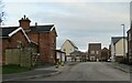
New housing development on old station site
New properties under construction at West Tanfield. The late Ben Brooksbank photographed the station building back in 1995 and that doesn't appear to have changed much, but beyond, on what originally seems to have been a small siding and possible goods shed [according to old maps], there is now new housing development.
Image: © Gordon Hatton
Taken: 3 Feb 2023
0.03 miles
3
Tanfield railway station (site), Yorkshire
Opened in 1875 by the North Eastern Railway on the short Melmerby-Masham branch (off the Leeds-Harrogate-Northallerton line), this station closed to passengers in 1931, long before Dr. Beeching. It continued for goods until 1963. Forecourt.
Image: © Nigel Thompson
Taken: 21 Sep 2008
0.03 miles
4
![West Tanfield buildings [8]](https://s0.geograph.org.uk/geophotos/07/33/30/7333048_f8c433f2_120x120.jpg)
West Tanfield buildings [8]
Now used as meeting rooms, this former Wesleyan chapel in Mowbray Terrace was replaced by the adjacent church Image and Image Built in the early 19th century of squared, coursed rubble stone with ashlar dressings, under a stone slate roof. Inside is a panelled gallery supported by cast-iron Doric columns. Listed, grade II, with details at: https://historicengland.org.uk/listing/the-list/list-entry/1293821
West Tanfield is a village in the Hambleton district of North Yorkshire, some 5½ miles northwest of Ripon. The village is sited on the north bank of the Rive Ure, astride the A6108 road from Ripon to Leyburn. The village name comes from the Anglo-Saxon 'tana feld', which mean "open land where young shoots grow" and is referred to in the Domesday Book. West Tanfield is home to the Marmion Tower, a 15th century gatehouse to the demolished manor house.
Image: © Michael Dibb
Taken: 24 Jun 2022
0.06 miles
5

Looking north up Mowbray Terrace, West Tanfield
The building in the centre of the photograph is the Methodist Church.
Image: © C P Smith
Taken: 13 Apr 2011
0.06 miles
6
![West Tanfield buildings [6]](https://s2.geograph.org.uk/geophotos/07/33/30/7333046_73407195_120x120.jpg)
West Tanfield buildings [6]
West Tanfield Methodist Church, Mowbray Terrace, was built in the early 20th century, replacing the former chapel Image Constructed of squared, coursed rubble stone with ashlar dressings under a slate roof.
West Tanfield is a village in the Hambleton district of North Yorkshire, some 5½ miles northwest of Ripon. The village is sited on the north bank of the Rive Ure, astride the A6108 road from Ripon to Leyburn. The village name comes from the Anglo-Saxon 'tana feld', which mean "open land where young shoots grow" and is referred to in the Domesday Book. West Tanfield is home to the Marmion Tower, a 15th century gatehouse to the demolished manor house.
Image: © Michael Dibb
Taken: 24 Jun 2022
0.06 miles
7
![West Tanfield buildings [7]](https://s3.geograph.org.uk/geophotos/07/33/30/7333047_37fb4731_120x120.jpg)
West Tanfield buildings [7]
West Tanfield Methodist Church, Mowbray Terrace, was built in the early 20th century, replacing the former chapel Image Constructed of squared, coursed rubble stone with ashlar dressings under a slate roof.
West Tanfield is a village in the Hambleton district of North Yorkshire, some 5½ miles northwest of Ripon. The village is sited on the north bank of the Rive Ure, astride the A6108 road from Ripon to Leyburn. The village name comes from the Anglo-Saxon 'tana feld', which mean "open land where young shoots grow" and is referred to in the Domesday Book. West Tanfield is home to the Marmion Tower, a 15th century gatehouse to the demolished manor house.
Image: © Michael Dibb
Taken: 24 Jun 2022
0.06 miles
8

West Tanfield Methodist Church
The Methodist Chapel was built in 1798. Located on Mowbray Terrace, it is a Grade II Listed building (English Heritage Building ID: 332698 http://www.britishlistedbuildings.co.uk/en-332698-old-wesleyan-chapel-west-tanfield-north- British Listed Buildings).
Image: © David Dixon
Taken: 30 Jun 2014
0.07 miles
9

The Methodist Church, Chapelgate, West Tanfield
The building to the left is the old chapel, which later became the Sunday School. It was built in the early 19C and is listed Grade II.
Image: © Humphrey Bolton
Taken: 28 Oct 2022
0.07 miles
10

Old Wesleyan Chapel (West Tanfield Methodist Church)
The Methodist Chapel was built in 1798. Located on Mowbray Terrace, it is a Grade II Listed building (English Heritage Building ID: 332698 http://www.britishlistedbuildings.co.uk/en-332698-old-wesleyan-chapel-west-tanfield-north- British Listed Buildings).
Image: © David Dixon
Taken: 30 Jun 2014
0.07 miles