IMAGES TAKEN NEAR TO
Kirkby Malzeard, RIPON, HG4 3QL
Introduction
This page details the photographs taken nearby to HG4 3QL by members of the Geograph project.
The Geograph project started in 2005 with the aim of publishing, organising and preserving representative images for every square kilometre of Great Britain, Ireland and the Isle of Man.

There are currently over 7.5m images from over14,400 individuals and you can help contribute to the project by visiting https://www.geograph.org.uk
Image Map
Images are licensed for reuse under creativecommons.org/licenses/by-sa/2.0
Notes
- Clicking on the map will re-center to the selected point.
- The higher the marker number, the further away the image location is from the centre of the postcode.
Image Listing (12 Images Found)
Images are licensed for reuse under creativecommons.org/licenses/by-sa/2.0
Image
Details
Distance
1
Laverton, Stainmoor House
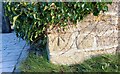
The benchmark is cut into the 2nd course of stone, into a left hand cornerstone of the house https://www.geograph.org.uk/photo/7118838.
Image: © Mel Towler
Taken: 9 Feb 2022
0.15 miles
2
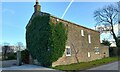
Laverton, Stainmoor House
There is a benchmark https://www.geograph.org.uk/photo/7118834 cut into the 2nd course of stone, into a left hand cornerstone of the house. It is directly below the ivy.
Image: © Mel Towler
Taken: 9 Feb 2022
0.15 miles
3
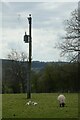
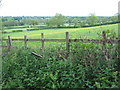
Ewe, lambs and electricity pole
Looking across a field beside Kirkby Moor Road.
Image: © DS Pugh
Taken: 15 Apr 2022
0.15 miles
4
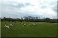
Sheep beside Kirkby Moor Road
Looking across a field of ewes and lambs to the south of the road.
Image: © DS Pugh
Taken: 15 Apr 2022
0.16 miles
5
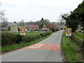
Entering Kirkby Malzeard
Entering the village from Laverton.
Image: © Chris Heaton
Taken: 25 Apr 2012
0.16 miles
6
Country lane into Kirkby Malzeard
From Laverton heading north
Image: © Martin Dawes
Taken: 11 Nov 2016
0.16 miles
7
Kirkby Malzeard from old Quarry
A view over the field towards the village of Kirkby Malzeard. This is taken from the path which traverses the old Kirkby Malzeard Quarry.Part of a circular walk around the boundaries of Kirkby Malzeard.The flower meadows and Blue bells enhance the view.
Image: © roger nightingale
Taken: 30 May 2010
0.22 miles
8
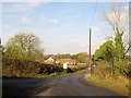
Road junction in Kirkby Malzeard
At the west end of the village.
Image: © philandju
Taken: 2 Oct 2015
0.24 miles
9
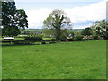
View over fields at Kirkby Malzeard
A view from field path towards Kirkby Malzeard playing fields and farm buildings.Houses in the centre right are the back of Kirkby Malzeard. In the distance the rising hills above Kex Beck and Ringbeck.
Image: © roger nightingale
Taken: 30 May 2010
0.24 miles
10
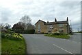
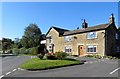
Western end of the village
Ringbeck Road is to the right.
Image: © DS Pugh
Taken: 15 Apr 2022
0.24 miles