IMAGES TAKEN NEAR TO
Lofthouse, HARROGATE, HG3 5RG
Introduction
This page details the photographs taken nearby to HG3 5RG by members of the Geograph project.
The Geograph project started in 2005 with the aim of publishing, organising and preserving representative images for every square kilometre of Great Britain, Ireland and the Isle of Man.

There are currently over 7.5m images from over14,400 individuals and you can help contribute to the project by visiting https://www.geograph.org.uk
Image Map (Loading...)


Getting Data...Please wait
Leaflet Map data © OpenStreetMap
Images are licensed for reuse under creativecommons.org/licenses/by-sa/2.0
Notes
- Clicking on the map will re-center to the selected point.
- The higher the marker number, the further away the image location is from the centre of the postcode.
Image Listing (31 Images Found)
Images are licensed for reuse under creativecommons.org/licenses/by-sa/2.0
Image
Details
Distance
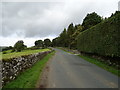
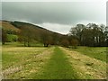
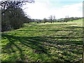
2
Farmland in Nidderdale
Looking across fields from the roaf between Lofthouse and Ramsgill.
Image: © DS Pugh
Taken: 27 Dec 2018
0.06 miles
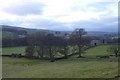
3
Dismantled railway.
along the Nidderdale way.
Image: © steven ruffles
Taken: 29 May 2011
0.07 miles
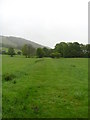
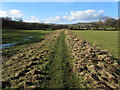
5
Line of Dismantled Railway
This is part of the Railway constructed in the Nidd Valley to transport men and materials during the construction of the Bradford Corporation Reservoirs at the turn of the 19th century
Image: © Michael Steele
Taken: 13 Mar 2009
0.08 miles
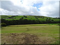
6
Former Route of Nidd Valley Light Railway
Now adopted by the Nidderdale Way long distance footpath - this clearly shows part of the course that the railway used to follow between Pateley Bridge and Scar House Reservoir. It was mainly used for transporting equipment and men to build the two huge stone dams at the top of the dale, but also did carry some passenger traffic. It was closed and dismantled after completion of the project.
Image: © Chris Heaton
Taken: 16 Feb 2014
0.09 miles
7
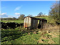
Ex Rolling Stock beside the Nidderdale Way
The line of the Nidd Valley Light Railway used to run not twenty yards from here before it was dismantled - I wonder if they left behind this rotting goods wagon.
Image: © Chris Heaton
Taken: 16 Feb 2014
0.09 miles
8
Nidd Valley Light Railway
Looking towards Lofthouse along the course of this former railway line, closed to passengers in 1929, goods traffic in 1936, and dismantled during 1937.
Image: © David Rogers
Taken: 11 Feb 2011
0.09 miles
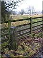
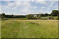
9
Nidderdale Way at Low Sikes
The Nidderdale Way is a 53-mile circular walk starting and finishing in Pateley Bridge.
The path takes walkers to Lofthouse.
Image: © Maigheach-gheal
Taken: 6 Apr 2011
0.10 miles
10
Path on the former Nidd Valley Light Railway
A disused goods carriage can be seen to the right of the photograph.
Image: © Mark Anderson
Taken: 11 Aug 2018
0.10 miles