IMAGES TAKEN NEAR TO
Kings Close, HARROGATE, HG3 5DA
Introduction
This page details the photographs taken nearby to Kings Close, HG3 5DA by members of the Geograph project.
The Geograph project started in 2005 with the aim of publishing, organising and preserving representative images for every square kilometre of Great Britain, Ireland and the Isle of Man.

There are currently over 7.5m images from over14,400 individuals and you can help contribute to the project by visiting https://www.geograph.org.uk
Image Map (Loading...)


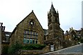
Getting Data...Please wait
Leaflet Map data © OpenStreetMap
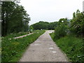
Images are licensed for reuse under creativecommons.org/licenses/by-sa/2.0
Notes
- Clicking on the map will re-center to the selected point.
- The higher the marker number, the further away the image location is from the centre of the postcode.
Image Listing (309 Images Found)
Images are licensed for reuse under creativecommons.org/licenses/by-sa/2.0
Image
Details
Distance
1
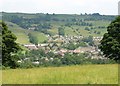
Pateley Bridge from the west
See Image; this is the view mentioned from a little further east along footpath 15 9/12/1. This is the northern side of the town, with fields leading up towards Brownstay Ridge above.
Image: © Derek Harper
Taken: 27 Jun 2011
0.04 miles
2
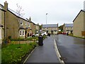
Millfield End
New houses built on the site of the Nidd Valley Light Railway
Image: © Kevin Waterhouse
Taken: 31 Oct 2023
0.06 miles
3
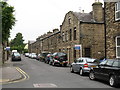
Millfield Street, Pateley Bridge
Victorian terrace houses most likely built for workmen employed at the large sandstone quarries above the town.
Image: © Gordon Hatton
Taken: 2 Jun 2008
0.08 miles
4
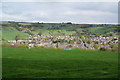
Pateley Bridge from the lower end of Ladies Riggs
There is a clear view of St Cuthbert's Church at the top of King Street.
Image: © Bill Boaden
Taken: 16 Apr 2011
0.08 miles
5
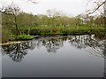
Top of the weir on the River Nidd
On the Nidderdale Way going upstream from Pateley Bridge
Image: © Martin Dawes
Taken: 6 May 2016
0.08 miles
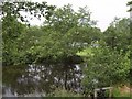
6
Top of the Weir - Pateley Bridge
On the River Nidd
Image: © Anthony Parkes
Taken: 26 May 2019
0.08 miles
7
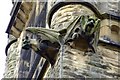
Gargoyles
Finely carved Gargoyles on the tower of a school building in Pateley Bridge.
Image: © Donnylad
Taken: 25 Jul 2007
0.09 miles
8
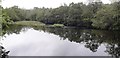
River Nidd
The top of the weir shown in Image; the abrupt edge of the reflected surface on the left shows where the river tips over the face of the weir. Behind the trees on the far side is Riverside Caravan Park.
Image: © Derek Harper
Taken: 27 Jun 2011
0.09 miles
9
Former course of the Nidd Valley Light Railway
From 1907 until 1929, Pateley Bridge was connected to the head of the dale by the Nidd Valley Light Railway with passenger services between the little town and Lofthouse. The original plan was for a 2'6" gauge line, but ended up as standard gauge, with the main purpose of carrying men and materials up to the Bradford Corporation dam construction sites at the head of the dale.
Image: © Gordon Hatton
Taken: 2 Jun 2008
0.09 miles
10
Gothic evidence
Victorian built school buildings in Pateley Bridge.
Image: © Donnylad
Taken: 25 Jul 2007
0.09 miles