IMAGES TAKEN NEAR TO
South Stainley, HARROGATE, HG3 3LX
Introduction
This page details the photographs taken nearby to HG3 3LX by members of the Geograph project.
The Geograph project started in 2005 with the aim of publishing, organising and preserving representative images for every square kilometre of Great Britain, Ireland and the Isle of Man.

There are currently over 7.5m images from over14,400 individuals and you can help contribute to the project by visiting https://www.geograph.org.uk
Image Map (Loading...)


Getting Data...Please wait
Leaflet Map data © OpenStreetMap
Images are licensed for reuse under creativecommons.org/licenses/by-sa/2.0
Notes
- Clicking on the map will re-center to the selected point.
- The higher the marker number, the further away the image location is from the centre of the postcode.
Image Listing (16 Images Found)
Images are licensed for reuse under creativecommons.org/licenses/by-sa/2.0
Image
Details
Distance
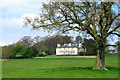
2
Stainley House
Grand House as seen from the Bridleway from Green Lane to Rakes Lane
Image: © manonabike
Taken: 27 Sep 2006
0.07 miles
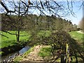
3
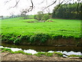
Stainley Beck
Looking across Stainley Beck from the Ripon Rowel Walk towards The Park Fields behind Stainley House.
Image: © David Rogers
Taken: 18 Apr 2009
0.09 miles
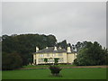
4
Towards Stainley House
Image: © Derek Harper
Taken: 1 Apr 2012
0.15 miles
5
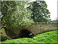
Stainley Beck Bridge
Bridge carries the BW from South Stainley to Brearton Gate, part of the Ripon Rowel Walk
Image: © manonabike
Taken: 18 Sep 2006
0.18 miles
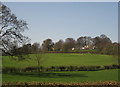
6
Ripon Rowel beside Stainley Beck
The long distance footpath approaching South Stainley through a small patch of woodland.
Image: © Chris Heaton
Taken: 7 Nov 2012
0.21 miles
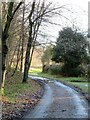
7
Stainley Gill
A (private) path climbs diagonally up through the steep wood which, like the narrow valley, is named Stainley Gill; it was planted, the notice says, in 1989. The lane carries bridleway 15 121/18/2 and the Ripon Rowel Walk into South Stainley.
Image: © Derek Harper
Taken: 1 Apr 2012
0.22 miles
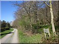
8
Stainley Gill
A little west of Image, with Stainley Beck to the left and the lane carrying bridleway 15 121/18/2 and the Ripon Rowel Walk on the right; ahead is an unnamed wood.
Image: © Derek Harper
Taken: 1 Apr 2012
0.23 miles
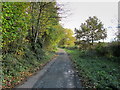
9
Bridleway at South Stainley
Bridleway and tarmacked farm road which at this point forms part of the Ripon Rowel Walk.
Image: © Gordon Hatton
Taken: 22 Jan 2021
0.23 miles
10
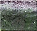
South Stainley, disused railway bridge
The rivet benchmark is cut into the southern parapet on the west side of the old line, and the cutmark faces north.
Image: © Mel Towler
Taken: 12 Feb 2023
0.24 miles