IMAGES TAKEN NEAR TO
Nidd, HARROGATE, HG3 3BD
Introduction
This page details the photographs taken nearby to HG3 3BD by members of the Geograph project.
The Geograph project started in 2005 with the aim of publishing, organising and preserving representative images for every square kilometre of Great Britain, Ireland and the Isle of Man.

There are currently over 7.5m images from over14,400 individuals and you can help contribute to the project by visiting https://www.geograph.org.uk
Image Map
Images are licensed for reuse under creativecommons.org/licenses/by-sa/2.0
Notes
- Clicking on the map will re-center to the selected point.
- The higher the marker number, the further away the image location is from the centre of the postcode.
Image Listing (4 Images Found)
Images are licensed for reuse under creativecommons.org/licenses/by-sa/2.0
Image
Details
Distance
1
Towards Flat Farm
I couldn't work it out on the ground, but somewhere on the right of the image is where the old Harrogate to Ripon railway used to run.
Image: © DS Pugh
Taken: 6 Sep 2006
0.14 miles
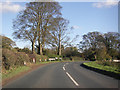
2

Towards Flat Farm
This is the view shown in Image at a different time of year, with leafless oaks along the far field boundary revealing a little more of the farm buildings. Taken a few metres from the B6165 at Nidd.
Image: © Derek Harper
Taken: 1 Apr 2012
0.15 miles
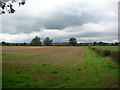
3

Field at Nidd
Looking to the right from the point where Image was taken. The course of the former Harrogate to Ripon railway is indicated by the trees along the far side of this arable field which awaits ploughing.
Image: © Derek Harper
Taken: 1 Apr 2012
0.23 miles