IMAGES TAKEN NEAR TO
Station Road, HARROGATE, HG3 2PW
Introduction
This page details the photographs taken nearby to Station Road, HG3 2PW by members of the Geograph project.
The Geograph project started in 2005 with the aim of publishing, organising and preserving representative images for every square kilometre of Great Britain, Ireland and the Isle of Man.

There are currently over 7.5m images from over14,400 individuals and you can help contribute to the project by visiting https://www.geograph.org.uk
Image Map (Loading...)


Getting Data...Please wait
Leaflet Map data © OpenStreetMap
Images are licensed for reuse under creativecommons.org/licenses/by-sa/2.0
Notes
- Clicking on the map will re-center to the selected point.
- The higher the marker number, the further away the image location is from the centre of the postcode.
Image Listing (26 Images Found)
Images are licensed for reuse under creativecommons.org/licenses/by-sa/2.0
Image
Details
Distance
1
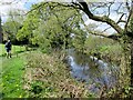
Nidderdale Way passing houses on Niddside
The Nidderdale Way continues on the riverside path to Summer Bridge
Image: © Martin Dawes
Taken: 5 May 2016
0.02 miles
2
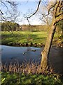
River Nidd near Darley
Looking directly the stretch of the river shown in Image The conifer plantation across the meadows is Spring Wood.
Image: © Derek Harper
Taken: 5 Apr 2012
0.03 miles
3
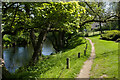
Footpath near Niddside
This footpath runs between the Nidd and houses on Niddside.
Image: © Mark Anderson
Taken: 31 May 2021
0.03 miles
4
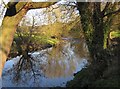
River Nidd near Darley
From the Nidderdale Way following footpath 15 91/55/1 along the right bank of the river.
Image: © Derek Harper
Taken: 5 Apr 2012
0.04 miles
5
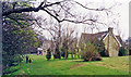
Darley railway station (site), Yorkshire
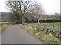
Opened in 1862 by the North Eastern Railway on its line from Harrogate to Pateley Bridge, the station is believed to have been situated roughly where the modern house now stands. It closed to passengers in 1950. Taken looking north along Station Road. Just out of sight to the left, the old formation can be more clearly seen.
Image: © Nigel Thompson
Taken: 23 Feb 2013
0.04 miles
6
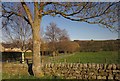
Niddside, Darley
From Station Road, which (see Image) leads down here from the village of Darley. A group of four houses occupies the area close to the site of the former Darley Station - the only remaining station is an electricity sub-one.
Image: © Derek Harper
Taken: 5 Apr 2012
0.04 miles
7
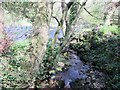
Fringill Dike entering River Nidd
A small footbridge here for the Nidderdale Way
Image: © Martin Dawes
Taken: 5 May 2016
0.06 miles
8
Nidderdale Way with dismantled railway to the left
North of Darley
Image: © Martin Dawes
Taken: 5 May 2016
0.07 miles
9
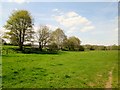
Site of former Darley station
View eastward along track of ex-NER Pateley Bridge branch from Harrogate. The station seemingly where the new houses are, closed 2/4/51 to passengers (goods 2/10/53); goods continued to Pateley Bridge until 31/10/64.
Image: © Ben Brooksbank
Taken: 28 Apr 1995
0.08 miles
10
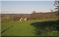
View near Darley
From Station Road just below the built-up area of Darley, looking down the Nidd valley, with one of the houses on Niddside. On the left, across the river, are a cluster of buildings around White Oak and Birchfield Farms.
Image: © Derek Harper
Taken: 5 Apr 2012
0.09 miles