IMAGES TAKEN NEAR TO
Levens Close, HARROGATE, HG3 2BN
Introduction
This page details the photographs taken nearby to Levens Close, HG3 2BN by members of the Geograph project.
The Geograph project started in 2005 with the aim of publishing, organising and preserving representative images for every square kilometre of Great Britain, Ireland and the Isle of Man.

There are currently over 7.5m images from over14,400 individuals and you can help contribute to the project by visiting https://www.geograph.org.uk
Image Map (Loading...)


Getting Data...Please wait
Leaflet Map data © OpenStreetMap
Images are licensed for reuse under creativecommons.org/licenses/by-sa/2.0
Notes
- Clicking on the map will re-center to the selected point.
- The higher the marker number, the further away the image location is from the centre of the postcode.
Image Listing (17 Images Found)
Images are licensed for reuse under creativecommons.org/licenses/by-sa/2.0
Image
Details
Distance
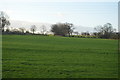
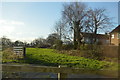
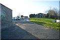
1
Lund Lane
At the junction with Myer's Green Lane
Image: © DS Pugh
Taken: 22 Feb 2014
0.03 miles
2
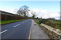
Along Lund Lane
Near the junction with Myer's Green Lane.
Image: © DS Pugh
Taken: 22 Feb 2014
0.04 miles
3
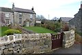
Cottage on Lund Lane
At the junction with Myer's Green Lane.
Image: © DS Pugh
Taken: 22 Feb 2014
0.04 miles
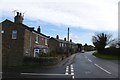
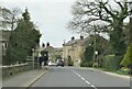
5
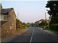
Lund Lane, Killinghall
A hamlet between Killinghall and Hampsthwaite.
Image: © Derek Harper
Taken: 29 Jun 2006
0.09 miles
7
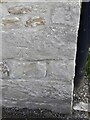
Lund Lane Killinghall/Hamspthwaite - benchmark
reasonable condition, about 3ft from ground level
Image: © Mel Towler
Taken: 11 Apr 2021
0.11 miles
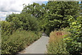
9
Lund Lane
There's a group of houses here forming a small settlement along Lund Lane. Not quite Hampsthwaite and not quite Killinghall, but within the latter parish.
Image: © Gordon Hatton
Taken: 21 Mar 2021
0.12 miles