IMAGES TAKEN NEAR TO
New Mill Road, HOLMFIRTH, HD9 7AB
Introduction
This page details the photographs taken nearby to New Mill Road, HD9 7AB by members of the Geograph project.
The Geograph project started in 2005 with the aim of publishing, organising and preserving representative images for every square kilometre of Great Britain, Ireland and the Isle of Man.

There are currently over 7.5m images from over14,400 individuals and you can help contribute to the project by visiting https://www.geograph.org.uk
Image Map
Images are licensed for reuse under creativecommons.org/licenses/by-sa/2.0
Notes
- Clicking on the map will re-center to the selected point.
- The higher the marker number, the further away the image location is from the centre of the postcode.
Image Listing (70 Images Found)
Images are licensed for reuse under creativecommons.org/licenses/by-sa/2.0
Image
Details
Distance
2
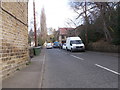
Recreation ground, Brockholes
This area has never been developed, providing an open space in the centre of the hamlet. It is in a 'bay' surrounded by a semicircle of cliff or steep slope at the junction with a side valley.
Image: © Humphrey Bolton
Taken: 5 Apr 2007
0.02 miles
3
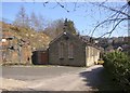
The former National School, Brockholes
The oval plaque reads “National School 1837”. It has now been replaced as a school by a new building up the hillside, and serves as a village hall.
Image: © Humphrey Bolton
Taken: 5 Apr 2007
0.02 miles
4
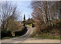
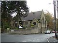
The approach to the church, Brockholes
St George's church is built on The Rock, and the way to it is along the lane past the National School and then up a drive between gateposts like those for a Victorian house.
Image: © Humphrey Bolton
Taken: 5 Apr 2007
0.02 miles
5
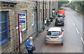
Bus stop by Rock Cottages, New Mill Road, Brockholes
Image: © Chris
Taken: 11 Sep 2014
0.03 miles
6
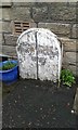
Old Boundary Marker
Parish Boundary Marker against the front wall of 347 Rock Terrace on the east side of the A616 New Mill Road, Brockholes. On the former boundary of Honley and Thurstonland townships, now in Holme Valley parish. Inscribed Boundary of Honley │ Boundary of Thurstonland / 1829 (below both and across the vertical line). Grade II Listed https://historicengland.org.uk/listing/the-list/list-entry/1134808.
Milestone Society National ID: YW_KIR03pb
Image: © D Garside
Taken: 7 Jan 2016
0.04 miles
8
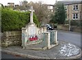
War Memorial, Brockholes
This is at the junction of Oakes Lane and Brockholes Lane, just inside the old Thurstonland township boundary.
Image: © Humphrey Bolton
Taken: 29 Nov 2005
0.05 miles
9
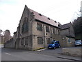
Brockholes Methodist Church
Brockholes started as a hamlet in Thurstonland township, but merged with Smithy Place in Honley township grew into an industrial village with its own church, chapel and school. This chapel uses the Perpendicular style, but in a 19C way. Note the basement room with access from the road, using the fall of the land to advantage, and the fine pair of (Chilean?) pine trees.
Image: © Humphrey Bolton
Taken: 29 Nov 2005
0.05 miles
10
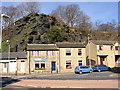
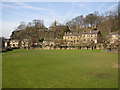
Houses under the Rock, Smithy Place, Brockholes
Called Far Rock on the 1850 map, this may well be a natural cliff.
Image: © Humphrey Bolton
Taken: 5 Apr 2007
0.05 miles