IMAGES TAKEN NEAR TO
Knoll Lane, HOLMFIRTH, HD9 3UR
Introduction
This page details the photographs taken nearby to Knoll Lane, HD9 3UR by members of the Geograph project.
The Geograph project started in 2005 with the aim of publishing, organising and preserving representative images for every square kilometre of Great Britain, Ireland and the Isle of Man.

There are currently over 7.5m images from over14,400 individuals and you can help contribute to the project by visiting https://www.geograph.org.uk
Image Map
Images are licensed for reuse under creativecommons.org/licenses/by-sa/2.0
Notes
- Clicking on the map will re-center to the selected point.
- The higher the marker number, the further away the image location is from the centre of the postcode.
Image Listing (14 Images Found)
Images are licensed for reuse under creativecommons.org/licenses/by-sa/2.0
Image
Details
Distance
1
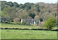
Holmroyd Wood, near Oldfield
The trees with dark green leaves in April must I think be holly, although these are normally below the deciduous trees of the wood.
Image: © Humphrey Bolton
Taken: 19 Apr 2009
0.03 miles
2
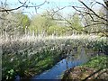
Lower end of New Dam, near Netherthong
The pool of water is stagnant, yet somewhere amongst the vegetation a fast-flowing stream can be heard. See also Image
Image: © Humphrey Bolton
Taken: 19 Apr 2009
0.09 miles
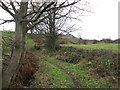
3
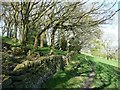
Footpath past part of Holmroyd Wood, near Oldfield
The part of the wood beyond the fence is 'wood pasture', with a good carpet of grass despite the close-set trees.
Image: © Humphrey Bolton
Taken: 19 Apr 2009
0.11 miles
4
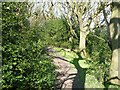
Footpath through Holmroyd Wood, near Oldfield
It seems that this wood is becoming a holly wood. See Image for a distant view.
Image: © Humphrey Bolton
Taken: 19 Apr 2009
0.11 miles
5
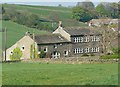
Former farmhouse near Netherthong
The farmhouse looks as if it might have been built for hand-loom weaving, with its long row of window-lights.
Image: © Humphrey Bolton
Taken: 19 Apr 2009
0.12 miles
6
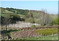
Upper end of New Dam, near Netherthong
New Dam is the name on a 1960s six-inch map, but it is named Holmroyd Reservoir on the 1850 map. I think that this reservoir stored water for Deanhouse Mills. It has been drained, but the bed is still wet judging by the stems of last year's bulrushes.
Image: © Humphrey Bolton
Taken: 19 Apr 2009
0.13 miles
7
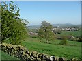
View towards Netherthong from a footpath near Oldfield
Looking across the valley of Dean Brook.
Image: © Humphrey Bolton
Taken: 19 Apr 2009
0.13 miles
8
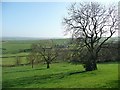
Row of trees, near Oldfield
Sometimes a row of trees like this indicates the line of a former hedgerow, but in this case the 1850 six-inch map does not show one.
Image: © Humphrey Bolton
Taken: 19 Apr 2009
0.13 miles
10
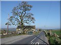
Moor Lane, Netherthong
The road from Honley via Wilshaw.
Image: © Humphrey Bolton
Taken: 19 Apr 2009
0.17 miles