IMAGES TAKEN NEAR TO
Dobb Top Road, HOLMFIRTH, HD9 2QP
Introduction
This page details the photographs taken nearby to Dobb Top Road, HD9 2QP by members of the Geograph project.
The Geograph project started in 2005 with the aim of publishing, organising and preserving representative images for every square kilometre of Great Britain, Ireland and the Isle of Man.

There are currently over 7.5m images from over14,400 individuals and you can help contribute to the project by visiting https://www.geograph.org.uk
Image Map
Images are licensed for reuse under creativecommons.org/licenses/by-sa/2.0
Notes
- Clicking on the map will re-center to the selected point.
- The higher the marker number, the further away the image location is from the centre of the postcode.
Image Listing (52 Images Found)
Images are licensed for reuse under creativecommons.org/licenses/by-sa/2.0
Image
Details
Distance
1
Housing on Bank Lane, Holmbridge
Newer housing above an older house.
Image: © Christine Johnstone
Taken: 26 Jun 2020
0.02 miles
2
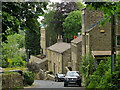
Bank Lane, Holmbridge
Looking downhill towards the centre of the village
Image: © Paul Harrop
Taken: 28 May 2023
0.05 miles
3
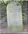
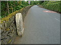
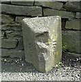
Old Milestone by the A6024, Woodhead Road, Holmbridge
Carved stone post by the A6024, in parish of HOLME VALLEY (KIRKLEES District), Woodhead Road, Holmbridge, at edge of narrow road, next to wall, 250m above church, on South side of road. Holmfirth gritstone, erected by the Huddersfield & Woodhead turnpike trust in the 18th century.
Inscription reads:-
8
Miles to
Huddersfield
Woodhead
5½
Grade II listed.
List Entry Number: 1229668 https://historicengland.org.uk/listing/the-list/list-entry/1229668
Milestone Society National ID: YW_HUWH08.
Image: © C Minto
Taken: 1 Nov 2001
0.08 miles
4
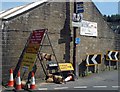
Clutter
Signs in abundance in Holmbridge.
Image: © Steve Fareham
Taken: 8 Jun 2008
0.08 miles
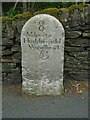
5
Old milestone
A view of the Huddersfield 8 miles milestone at Holmebridge. This shows the thickness of these gritstone stones and also the narrow A6024. No pavement must make it difficult for children to walk to school.
Image: © Chris Minto
Taken: 12 Jun 2022
0.08 miles
6
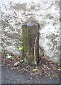
Old milestone
An original milestone from the 18/19C tollroad from Huddersfield to Woodhead. Note the ſ for s in Huddersfield. It is on the south side of the road about 200m southwest of the church in Holmbridge.
Inscription: 8 / Miles to / Huddersfield / Woodhead / 5½
Grade II listed 1229668. https://historicengland.org.uk/listing/the-list/list-entry/1229668
Milestone Society National ID: YW_HUWH08
Image: © Chris Minto
Taken: 12 Jun 2022
0.08 miles
7
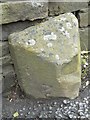
Old Boundary Marker
County Bridge Marker on A6024 Woodhead Road, Holmbridge. Holme Valley parish. Inscribed County vertically. The stone marks the extent of roadway adjoining the bridge that the County was obliged to maintain. See also https://www.geograph.org.uk/photo/1112612
Milestone Society National ID: YW_HOLM02br
Image: © R Heywood
Taken: 27 Aug 2019
0.10 miles
8
Old Boundary Marker by the A6024, Woodhead Road, Holme Valley Parish
Parish Boundary Marker by the A6024, in parish of Holme Valley (Kirklees District), Woodhead Road, Holmbridge, against stone wall. Inscribed AUSTONLEY AND HOLME on adjacent faces
Surveyed
Milestone Society National ID: YW_AUSHOL02pb
Image: © M Bardell
Taken: 19 Jul 2017
0.11 miles
9
Boundary stone, Woodhead Road, Holme
By c. 1910 the boundary between Holme and Austonley was at Holme Bridge and followed the rivers. However the 1850 six-inch map shows the boundary here, part way up the hill towards Holme village.
Image: © Humphrey Bolton
Taken: 23 Jul 2009
0.11 miles
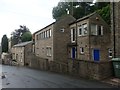
10
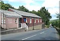
Holme Band Room, Woodhead Road, Holme
The band room was built by members and supporters in 1924; the datestone is inscribed 'Holme Band 1924'. The modern sign shows the current name 'Holme Silver Band'. The extension on the left evidently provides modern amenities perhaps lacking in the original building. The band was founded in 1865 by Samuel Broadhead. They were 2nd Section Champions of Great Britain in 1999, following which they were promoted to the 1st Section, and won the UK contest in 2009. See http://holme-band.co.uk/.
Image: © Humphrey Bolton
Taken: 23 Jul 2009
0.11 miles