IMAGES TAKEN NEAR TO
St. Johns Court, HUDDERSFIELD, HD8 0AZ
Introduction
This page details the photographs taken nearby to St. Johns Court, HD8 0AZ by members of the Geograph project.
The Geograph project started in 2005 with the aim of publishing, organising and preserving representative images for every square kilometre of Great Britain, Ireland and the Isle of Man.

There are currently over 7.5m images from over14,400 individuals and you can help contribute to the project by visiting https://www.geograph.org.uk
Image Map
Images are licensed for reuse under creativecommons.org/licenses/by-sa/2.0
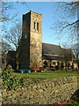
Notes
- Clicking on the map will re-center to the selected point.
- The higher the marker number, the further away the image location is from the centre of the postcode.
Image Listing (51 Images Found)
Images are licensed for reuse under creativecommons.org/licenses/by-sa/2.0
Image
Details
Distance
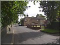
1
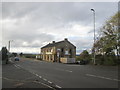
Wakefield Road/Rowley Lane junction
Rowley Lane to the left. The minor road to the right of the shop is Knotty Lane
Image: © John Slater
Taken: 22 Oct 2013
0.05 miles
2
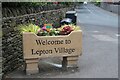
New village sign
Not a sign for a new village, but a new sign for an old village.
Image: © Terry
Taken: 30 May 2023
0.05 miles
3
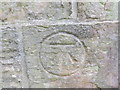
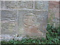
Ordnance Survey Cut Mark
This mark can be found on the wall of St John's Church in Lepton. The benchmark height is recorded as being 190.6097 metres above sea level.
For more detail see : http://www.bench-marks.org.uk/bm52086
Image: © Peter Wood
Taken: 6 Aug 2017
0.06 miles
6
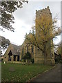
The Church of St John at Lepton
Viewed from the west.
Image: © Peter Wood
Taken: 6 Aug 2017
0.06 miles

8
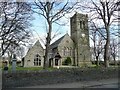
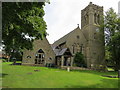
St John the Evangelist's Church, Green Balk Lane, Lepton
Pevsner missed this one, but from the Church website it was consecrated in November 1868. The tower was added in 1876 and the clock in 1920 as a war memorial. The spire became unsafe and was removed and a new top added to the tower in 1929. The extension to the left blends with the old church whilst being unmistakably 20C in style.
Image: © Humphrey Bolton
Taken: 10 Apr 2008
0.06 miles
9
Green Balk Lane, Lepton
Seen from its junction with Rowley Lane. The old house was called Green Balk on the 1850 map.
Image: © Humphrey Bolton
Taken: 14 Sep 2007
0.06 miles