IMAGES TAKEN NEAR TO
Manchester Road, HUDDERSFIELD, HD7 5QX
Introduction
This page details the photographs taken nearby to Manchester Road, HD7 5QX by members of the Geograph project.
The Geograph project started in 2005 with the aim of publishing, organising and preserving representative images for every square kilometre of Great Britain, Ireland and the Isle of Man.

There are currently over 7.5m images from over14,400 individuals and you can help contribute to the project by visiting https://www.geograph.org.uk
Image Map
Images are licensed for reuse under creativecommons.org/licenses/by-sa/2.0
Notes
- Clicking on the map will re-center to the selected point.
- The higher the marker number, the further away the image location is from the centre of the postcode.
Image Listing (46 Images Found)
Images are licensed for reuse under creativecommons.org/licenses/by-sa/2.0
Image
Details
Distance
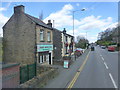
2
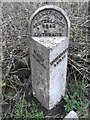
Milestone - Manchester Road, Linthwaite
Image: © Betty Longbottom
Taken: 8 Aug 2008
0.10 miles
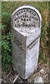
4
Old milestone
Another of the West Riding CC milestones in need of some tlc. This one is between Milnsbridge and Linthwaite opposite LP160. It is set at its full height with all 4 fixing points on the attachment into the backing stone visible. There will be 20cm of backing stone under soil level. It is Grade II listed 1217380.
Image: © Chris Minto
Taken: 26 Mar 2014
0.13 miles
5
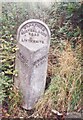
Old Milestone, A62, Manchester Road, between Milnsbridge & Linthwaite
Located on the South side of road, opposite LP160. Metal plate attached to stone post, Brayshaw & Booth casting design, 19th century. Alternative view see http://www.geograph.org.uk/photo/915074
Inscription reads: OLDHAM / 14½ // HUDDERSFIELD / 3 MILES // WAKEFIELD / & / AUSTERLANDS / ROAD / LINTHWAITE // BRAYSHAW & BOOTH / MAKERS / LIVERSEDGE
Grade II listed by Historic England. see https://historicengland.org.uk/listing/the-list/list-entry/1217380
Milestone Society National ID: YW_HUOD03
Image: © Christine Minto
Taken: 4 Feb 2006
0.13 miles
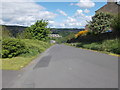
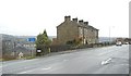
6
Milnsbridge - Manchester Road from Britannia Road
Image: © Dave Bevis
Taken: 22 Aug 2011
0.14 miles
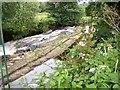
7
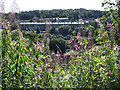
Canal Overflow near Ramsden Mills, Golcar
At intervals along canals there is a weir alongside the towpath to reglaute the water level. The flags cover a culvert under the towpath, discharging to the adjacent River Colne.
Image: © Humphrey Bolton
Taken: 12 Jul 2007
0.14 miles
8
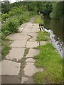
Weir on the River Colne near Ramsden Mills, Golcar
The weir seems to consist of a mound of concrete with a rounded sill. The channel leads via a penstock into the disused millpond for Ramsden Mills.
Image: © Humphrey Bolton
Taken: 12 Jul 2007
0.14 miles
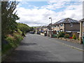
9
Cowlersley Lane, Linthwaite
This road climbs steadily from Milnsbridge and eventually reaches the old turnpike road at Blackmoorfoot. It was perhaps a feeder road from the townships on the western side of Huddersfield. These isolated terraces of houses often occur, and might be the result of the builder buying up a small piece of land that was not much good for farming – in this case it was rough land hemmed in by quarries along Guy Edge. The modern houses down Slant Gate on the left were built on quarried land.
Image: © Humphrey Bolton
Taken: 6 Dec 2007
0.14 miles