IMAGES TAKEN NEAR TO
Lower Fold, BRIGHOUSE, HD6 3PN
Introduction
This page details the photographs taken nearby to Lower Fold, HD6 3PN by members of the Geograph project.
The Geograph project started in 2005 with the aim of publishing, organising and preserving representative images for every square kilometre of Great Britain, Ireland and the Isle of Man.

There are currently over 7.5m images from over14,400 individuals and you can help contribute to the project by visiting https://www.geograph.org.uk
Image Map
Images are licensed for reuse under creativecommons.org/licenses/by-sa/2.0
Notes
- Clicking on the map will re-center to the selected point.
- The higher the marker number, the further away the image location is from the centre of the postcode.
Image Listing (249 Images Found)
Images are licensed for reuse under creativecommons.org/licenses/by-sa/2.0
Image
Details
Distance
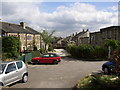
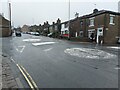
1
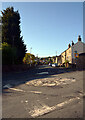
The junction of Slade Lane and the A643, Rastrick
Image: © habiloid
Taken: 7 May 2022
0.04 miles
3
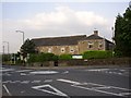
St Winifred's Nursing Home, Rastrick
This has been made out of a group of buildings off the top of Crowtrees lane, next to the crossroads now 'decorated' by a double mini-roundabout. The buildings include the former house and barn of Oaks Green Farm, the land of which was built on c. 1965, ie Oaks Green Mount and Carr Green Drive, Avenue and Close.
Image: © Humphrey Bolton
Taken: 8 Jun 2006
0.05 miles
4
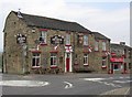
The Greyhound Inn, Rastrick
This is on the A643 at the top of Crowtrees Lane. The pub is dressed up for the World Cup.
Image: © Humphrey Bolton
Taken: 12 Jun 2006
0.05 miles
5
Stonelea Drive, Rastrick
This was formerly Delf Road, off the top of Delf Hill, but now has access from Crowtrees Lane. The cottages on the left were built in the 18C, and the ones on the right are of the early 19C with large flat-roofed extensions at the rear (they front onto Crowtrees Lane).
Image: © Humphrey Bolton
Taken: 25 Apr 2007
0.05 miles
6
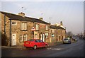
Cottages. Crowtrees Lane, Rastrick
These are all on the 1824 map, and likely to be of the 18C, but the ones on the left will have had new, larger, windows inserted.
Image: © Humphrey Bolton
Taken: 14 Dec 2007
0.05 miles
7
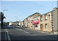
The sandwich shop, Crowtrees Lane, Rastrick
My favourite is bacon and mushroom. The Greyhound is next door, then the double-mini roundabout with Delf Hill to the right, New Hey Road straight on and Slade Lane left.
Image: © Humphrey Bolton
Taken: 20 Sep 2008
0.05 miles
8
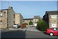
Stonelea Drive, Crowtrees Lane, Rastrick
Although it leads to old houses, this is a modern street. The houses were on Delf Road, off Delf Hill, but that access was closed off and replaced by this one, presumably on road safety grounds.
Image: © Humphrey Bolton
Taken: 20 Sep 2008
0.05 miles
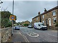
10
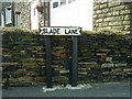
An' we're all crazee now!
Slade Lane in Rastrick, but I didn't see Noddy Holder hanging around.
Image: © Matthew Hatton
Taken: 29 Aug 2009
0.05 miles