IMAGES TAKEN NEAR TO
Mayster Road, BRIGHOUSE, HD6 3PF
Introduction
This page details the photographs taken nearby to Mayster Road, HD6 3PF by members of the Geograph project.
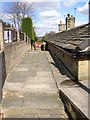
The Geograph project started in 2005 with the aim of publishing, organising and preserving representative images for every square kilometre of Great Britain, Ireland and the Isle of Man.

There are currently over 7.5m images from over14,400 individuals and you can help contribute to the project by visiting https://www.geograph.org.uk
Image Map
Images are licensed for reuse under creativecommons.org/licenses/by-sa/2.0
Notes
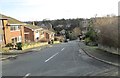
- Clicking on the map will re-center to the selected point.
- The higher the marker number, the further away the image location is from the centre of the postcode.
Image Listing (237 Images Found)
Images are licensed for reuse under creativecommons.org/licenses/by-sa/2.0
Image
Details
Distance
2
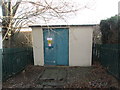
Electricity Substation No 1892 - Mayster Grove
Image: © Betty Longbottom
Taken: 24 Dec 2013
0.03 miles
3
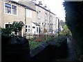
Tofts Grove Place, Rastrick
These houses turn their back on the road, there are no doors facing that way and few windows. Instead they face a little walled footpath. Moving house must be difficult!
Image: © Humphrey Bolton
Taken: 12 Nov 2005
0.03 miles
4
Snicket from Mayster Road to Newbury Road, Rastrick
Detailed exploration leads to surprising discoveries - here a path has been constructed behind 'back-to-earth' houses along Tofts Grove. It turns left at the wall decorated by graffiti and leads between gardens to Newbury Road. (Snicket is one of many words for a narrow path between walls or houses. I grew up with it in Baildon, Yorkshire)
Image: © Humphrey Bolton
Taken: 10 Apr 2006
0.03 miles
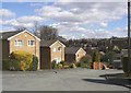
7
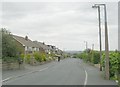
Mayster Grove, Rastrick (SE135215)
In this part of the road the type of house has changed - detached instead of semis, and end-on to the road to reduce the frontage and fit more houses into the site.
Image: © Humphrey Bolton
Taken: 27 Feb 2006
0.05 miles
8
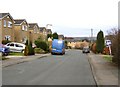
Bottom End of Tofts Grove, Rastrick
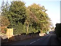
On the left behind the trees are modern houses in the grounds of Holly Bank - they each have their patch of woodland. At the bottom of the hill is the junction with Field Lane, with recently-built houses behind.
Image: © Humphrey Bolton
Taken: 12 Nov 2005
0.06 miles
9
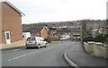
End of Newbury Road, Rastrick
Here it is good to see that the developer has provided a stepped path from the end of the road down to Tofts Grove, and also, to the left of the photo, up to Mayster Grove. The backs of houses along Crowtrees Lane can be seen in the distance.
Image: © Humphrey Bolton
Taken: 10 Apr 2006
0.06 miles