IMAGES TAKEN NEAR TO
Raw Hill, BRIGHOUSE, HD6 3NQ
Introduction
This page details the photographs taken nearby to Raw Hill, HD6 3NQ by members of the Geograph project.
The Geograph project started in 2005 with the aim of publishing, organising and preserving representative images for every square kilometre of Great Britain, Ireland and the Isle of Man.

There are currently over 7.5m images from over14,400 individuals and you can help contribute to the project by visiting https://www.geograph.org.uk
Image Map
Images are licensed for reuse under creativecommons.org/licenses/by-sa/2.0
Notes
- Clicking on the map will re-center to the selected point.
- The higher the marker number, the further away the image location is from the centre of the postcode.
Image Listing (217 Images Found)
Images are licensed for reuse under creativecommons.org/licenses/by-sa/2.0
Image
Details
Distance
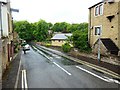
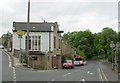
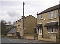
3
The former Lower George Inn, Jumble Dyke. Rastrick
This is captioned P.H. on the 1893 and 1918 1:2500 maps. It closed in 1926. It is aligned with Raw Hill, which is no longer a street, rather than with Jumble Dyke.
Image: © Humphrey Bolton
Taken: 17 Dec 2019
0.01 miles
4
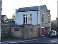
House on the corner of Jumble Dyke and Church Street
Image: © Alexander P Kapp
Taken: 27 Oct 2008
0.01 miles
5
Jumble Dyke - Crowtrees Lane, Rastrick
Image: © Betty Longbottom
Taken: 14 May 2008
0.01 miles
6
Rastrick, Church Street
The miniature town centre of Rastrick is towards the NE corner of the square, in a bottleneck where the old and new roads through the township join together for a short distance. The former Rastrick Grammar School, now an independent prep. school, is in the background.
Image: © Humphrey Bolton
Taken: 16 Aug 2005
0.02 miles
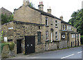
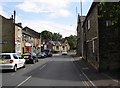
7
Jumble Dyke, Rastrick
Part of the old road from Brighouse to Elland, turnpiked in the 18C but superseded by a new road in the Calder Valley in the 19C. I would be interested to know what the building on the left was – evidently a shop of some sort, with a blocked taking-in door and a girder for a hoist. The 1850 six-inch map shows a Smithy here. If you look at Image, at the corner of the road junction, probably in front of the steps, there was a turnpike road guide stone shown on the 1933 1:2500 map but probably taken away during the Second World War. I hope it in safe keeping, but where? On the Crowtrees Lane side "T Brook Sculptor, To JUNCTION 13 Miles, LEEDS 13 Miles, Anno Domini" On the Jumble Dyke side "To LEEDS 13 Miles, ELLAND 2 Miles, 1823".
Image: © Humphrey Bolton
Taken: 22 Jan 2007
0.02 miles
8
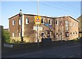
Rastrick Parish Centre, Church Street, Rastrick
The church hall for St Matthew's Church (CofE and Methodist). On the site of Rastrick Church School, which opened in 1867 in the Sunday School building of 1865, which was in the Gothic style. It closed following the opening of Carr Green School in 1912, and the building was demolished in 1960 to make way for the present building.
Image: © Humphrey Bolton
Taken: 22 Jan 2007
0.02 miles
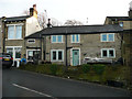
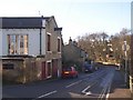
9
Top of Jumble Dyke, Rastrick
This was taken from the junction with Church Street. I thought that the house behind the telephone pole was the Lower George Inn, as it still has brackets for what might have been an inn sign on the wall, but old maps show that the inn was on the other side of the road, see Image
Image: © Humphrey Bolton
Taken: 25 Feb 2007
0.02 miles
10
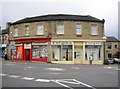
The former Co-op, Church Street / Thornhill Road, Rastrick
Built with the front curving round from Church Street to Thornhill Road. The old nameplate for Thornhill Road is still on the wall. The entrance on the right was into the drapery department.
Image: © Humphrey Bolton
Taken: 8 Jul 2007
0.02 miles