IMAGES TAKEN NEAR TO
Crowtrees Lane, BRIGHOUSE, HD6 3LW
Introduction
This page details the photographs taken nearby to Crowtrees Lane, HD6 3LW by members of the Geograph project.
The Geograph project started in 2005 with the aim of publishing, organising and preserving representative images for every square kilometre of Great Britain, Ireland and the Isle of Man.

There are currently over 7.5m images from over14,400 individuals and you can help contribute to the project by visiting https://www.geograph.org.uk
Image Map
Images are licensed for reuse under creativecommons.org/licenses/by-sa/2.0
Notes
- Clicking on the map will re-center to the selected point.
- The higher the marker number, the further away the image location is from the centre of the postcode.
Image Listing (220 Images Found)
Images are licensed for reuse under creativecommons.org/licenses/by-sa/2.0
Image
Details
Distance
1
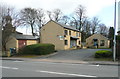
Unity Court, Rastrick
This is on the site of a Corporation depot, and is a block of four small flats and a bungalow. The electricity sub-station is older, but has been faced with the same artificial stone as the houses.
Image: © Humphrey Bolton
Taken: 6 Mar 2017
0.01 miles
2
Car park, Rastrick
This free car park is on the site of the Upper George Inn, which closed in 1936.
Image: © Humphrey Bolton
Taken: 6 Mar 2017
0.01 miles
4
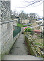
Path from Crowtrees Lane to Jumble Dyke, Rastrick
See also Image for an earlier view. This path is not designated as a public footpath, but is well used and obviously a public way. Despite this the landowner closed in a fenced it off, causing a public outcry. Fortunately the council found enough evidence for it to be classed as a public highway, and it was re-opened.
Image: © Humphrey Bolton
Taken: 6 Mar 2017
0.02 miles
5
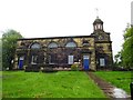
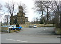
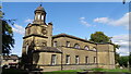
The Anglican and Methodist Church of St Matthew, Rastrick
Image: © Bill Henderson
Taken: 8 May 2014
0.03 miles
8
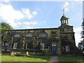
The south side of St Matthew's Church, Rastrick
The first church was built c.1350, nearer the road next to the Saxon cross. It was rebuilt in 1606 and then this present building replaced it in 1798. The churchyard was extended in 1823 and again in 1862. There is a very detailed history of the church by Richrd Kay:-
https://www.stmatthewsrastrick.org/599102199077.htm
Image: © Humphrey Bolton
Taken: 21 Jul 2023
0.03 miles
9
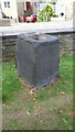
Cross Base
A massive base in the churchyard of St Matthew's
Image: © Kevin Waterhouse
Taken: 29 Aug 2018
0.03 miles
10
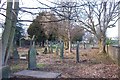
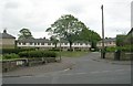
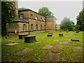
St Matthew's Churchyard, Vegetation Cleared
The Church community, with the help of the Probation Service have recently been putting a lot of effort into clearing litter, debris and vegetation from the previously overgrown Churchyard. the photo is taken at the south end facing north.
Image: © Richard Kay
Taken: 26 Feb 2008
0.03 miles