IMAGES TAKEN NEAR TO
Ogden Lane, BRIGHOUSE, HD6 3HF
Introduction
This page details the photographs taken nearby to Ogden Lane, HD6 3HF by members of the Geograph project.
The Geograph project started in 2005 with the aim of publishing, organising and preserving representative images for every square kilometre of Great Britain, Ireland and the Isle of Man.

There are currently over 7.5m images from over14,400 individuals and you can help contribute to the project by visiting https://www.geograph.org.uk
Image Map
Images are licensed for reuse under creativecommons.org/licenses/by-sa/2.0
Notes
- Clicking on the map will re-center to the selected point.
- The higher the marker number, the further away the image location is from the centre of the postcode.
Image Listing (210 Images Found)
Images are licensed for reuse under creativecommons.org/licenses/by-sa/2.0
Image
Details
Distance
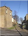
1
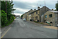
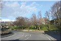
Ogden Lane, Rastrick
This is a revisit to the subject of the first geograph for the square: Image The main change is that a house has been built on the right, part of a redevelopment of the site of a forge. This road was originally the main road through Rastrick on its way to Elland, and later also to New Hey in Lancashire. There is a milestone on the left near the top of the hill.
Image: © Humphrey Bolton
Taken: 24 Jun 2021
0.01 miles
2
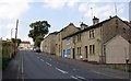
Ogden Lane, Rastrick
This is part of the old main road up through Rastrick. It was turnpiked in the early 19C, and was the A643 until the mid-20C when the parallel road to the W received that dubious honour. The photo was taken from the junction with Toothill Bank at the foot of the hill. The building to the right of the parked vehicles is the former Rastrick lock-up, the window of which is still just visible at pavement level.
Image: © Humphrey Bolton
Taken: 17 Aug 2005
0.02 miles
3
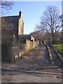
Foot of Bowling Alley, Rastrick
Bowling Alley is an old lane up the hillside from Rastrick Common; it has been downgraded to a public footpath, although it is a bridleway in character.
Image: © Humphrey Bolton
Taken: 22 Jan 2007
0.02 miles
4
Stackgarth, Rastrick
A short unmade street off Ogden Lane. The house on the left was the offices of Rastrick Local Board from 1863 until the formation of Brighouse Borough in 1893. The village lock-up was in the basement, so the blocked doorway (at the extreme left of the photograph) probably led down to it.
Image: © Humphrey Bolton
Taken: 22 Jan 2007
0.02 miles
5
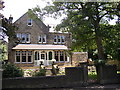
House, Rastrick Common, Rastrick
A pleasant arrangement of a porch, with wooden arches and railings, between bay windows.
Image: © Humphrey Bolton
Taken: 16 Jul 2007
0.02 miles
6
Site of smithy, Ogden Lane
The last working smithy in the area was here, at the junction of Ogden Lane and Rastrick Common. It was run by G S Whiteley and Co., established by George Whiteley c. 1860. The business passed to his nephew John Riley, and then his son Clifford Riley, who wrote a very interesting book “A Village Blacksmith”. Finally, when Clifford retired, his nephew John Snell took over, but died of heart disease in 1995 at only 38 years of age. Neighbours had been complaining about the noise, and no buyer was found for the business. All the buildings were demolished as they could have been dangerous if left derelict. The main work was tool-making and maintenance, initially for the local quarries, supplemented increasingly by fabrication work. Wrought iron work included the weather-vane for St Matthew's Church. The one type of work that was never done was the shoeing of horses. The land is owned by the Mary Law Charity.
Image: © Humphrey Bolton
Taken: 16 Jul 2007
0.02 miles
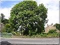
7
Green, Rastrick Common, Rastrick
Not an old village green, but a landscaped area created after a row of cottages was demolished.
Image: © Humphrey Bolton
Taken: 24 Mar 2008
0.02 miles
8
Green (2), Rastrick Common, Rastrick
Not an old village green, but a landscaped area created after a row of cottages was demolished.
Image: © Humphrey Bolton
Taken: 24 Mar 2008
0.02 miles
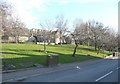
9
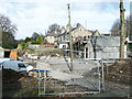
Houses under construction, Ogden Lane / Rastrick Common, Rzastrick
There were buildings here in the early 20C, cleared by 1933, and the site has remained empty ever since. To the left there was a smithy that specialised in tools for dressing stone, but also did wrought-iron work such as the weather vane for St Matthew's Church. On one occasion they were flooded from the culverted stream that runs through the site, so I hope this has been checked to make sure it is clear and in good condition.
Image: © Humphrey Bolton
Taken: 6 Mar 2017
0.03 miles