IMAGES TAKEN NEAR TO
Acre Lane, BRIGHOUSE, HD6 3FD
Introduction
This page details the photographs taken nearby to Acre Lane, HD6 3FD by members of the Geograph project.
The Geograph project started in 2005 with the aim of publishing, organising and preserving representative images for every square kilometre of Great Britain, Ireland and the Isle of Man.

There are currently over 7.5m images from over14,400 individuals and you can help contribute to the project by visiting https://www.geograph.org.uk
Image Map
Images are licensed for reuse under creativecommons.org/licenses/by-sa/2.0
Notes
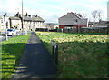
- Clicking on the map will re-center to the selected point.
- The higher the marker number, the further away the image location is from the centre of the postcode.
Image Listing (144 Images Found)
Images are licensed for reuse under creativecommons.org/licenses/by-sa/2.0
Image
Details
Distance
1
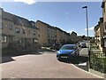
Acre Lane Houses, Rastrick
Frontages of the new houses are designed for cars, not for people I fear.
Image: © Richard Kay
Taken: 8 Aug 2023
0.01 miles
2
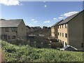
Acre Lane Housing Development, Rastrick
The back gardens have one thing in common - high fences.
Image: © Richard Kay
Taken: 8 Aug 2023
0.01 miles
3
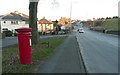
Letter box, Clough Lane A6107, Rastrick
An EiiR pillar box, HD6 282, of the older type with 'POST OFFICE' rather than 'ROYAL MAIL'. Beyond the electricity sub-station on the right you can see then cutting that was made when the road was widened in conjunction with the motorway construction.
Image: © Humphrey Bolton
Taken: 6 Jan 2009
0.04 miles
4
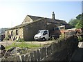
Lands Farm, New Hey Road
This farm appears to be derelict as seen from the road, but it is evidently in use, and I hope it is repaired rather than demolished.
Image: © Humphrey Bolton
Taken: 10 Jun 2006
0.05 miles
5
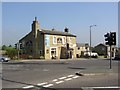
The Sun Inn, New Hey Road, Rastrick
This is at the cross-roads where the New Hey Road turnpike, built on a new line in 1806, crosses the medieval main road from Dewsbury to Elland, which was turnpiked in 1759. The traffic lights were installed when the motorway opened in 1973.
Image: © Humphrey Bolton
Taken: 10 Jun 2006
0.05 miles
6
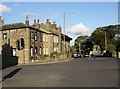
The western end of Clough Lane (A6107) Rastrick
The deeply overhanging eaves behind the lamp-post were perhaps a minor fashion at the end of the 19C - a reference to Swiss chalets, maybe.
Image: © Humphrey Bolton
Taken: 3 Sep 2006
0.05 miles
7
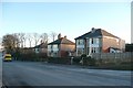
Semi-detached houses, Clough Lane A6107, Rastrick
Three pairs of semis, built probably in the 1930s.
Image: © Humphrey Bolton
Taken: 6 Jan 2009
0.05 miles
8
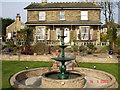
Elder Lea House
Elder Lea was built in 1885 by Albert Smith, a local millowner who had earlier built Lands House for himself (now a nursing home). Becoming the Mayor's House, it passed into the ownership of the Collins family in 1985. Run by the same family, Elder Lea House is the only 5 Star and Gold Award guest house in West Yorkshire, offering high quality affordable accommodation.
http://www.elderleahouse.com
Image: © D Collins
Taken: 14 Apr 2007
0.06 miles
9
Footway and 'grass triangle', Clough Lane / New Hey Road, Rastrick
Land was taken from 'Common Close' between 1918 and 1933 to make left turns from Clough lane to New Hey Road easier. Later houses were built on the field facing the two roads, but the corner was left undeveloped.
Image: © Humphrey Bolton
Taken: 28 Feb 2017
0.07 miles
10
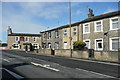
Houses on the north side of Clough Lane, Rastrick
These houses are near to the Sun Inn cross-roads. They were probably built in the early 19C, as buildings are shown here on the township map of 1824.
Image: © Humphrey Bolton
Taken: 28 Feb 2017
0.08 miles