IMAGES TAKEN NEAR TO
Wood Bottom Lane, BRIGHOUSE, HD6 2QW
Introduction
This page details the photographs taken nearby to Wood Bottom Lane, HD6 2QW by members of the Geograph project.
The Geograph project started in 2005 with the aim of publishing, organising and preserving representative images for every square kilometre of Great Britain, Ireland and the Isle of Man.

There are currently over 7.5m images from over14,400 individuals and you can help contribute to the project by visiting https://www.geograph.org.uk
Image Map
Images are licensed for reuse under creativecommons.org/licenses/by-sa/2.0
Notes
- Clicking on the map will re-center to the selected point.
- The higher the marker number, the further away the image location is from the centre of the postcode.
Image Listing (73 Images Found)
Images are licensed for reuse under creativecommons.org/licenses/by-sa/2.0
Image
Details
Distance
1
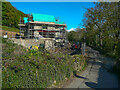
Houses under construction. Wood Bottom Lane, Hove Edge
Image: © Humphrey Bolton
Taken: 7 May 2021
0.03 miles
2
Wet Shod Lane, Brighouse
Since my previous photograph Image] all the trees and shrubs on the right have been cut down.
Image: © Humphrey Bolton
Taken: 2 May 2022
0.05 miles
3
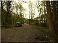
New track through woodland to Slead Mill, Brighouse
This gives a better access to Wet Shod Lane, via the industrial estate and Slead Mill yard. There was originally a footpath on this line, but it is now a little further to the north-east.
Image: © Humphrey Bolton
Taken: 2 May 2022
0.05 miles
4
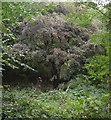
Hawthorn tree, Slead Syke Wood, Brighouse
This must be the tallest hawthorn tree that I have ever seen. The purple colour is the effect of the red berries amongst the green leaves.
Image: © Humphrey Bolton
Taken: 22 Sep 2007
0.07 miles
5
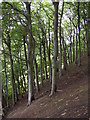
Beech trees, Slead Syke Wood, Brighouse
The hillside here is extremely steep. Note that the grid reference is approximate (location +/- 100m along the hillside).
Image: © Humphrey Bolton
Taken: 22 Sep 2007
0.07 miles
6
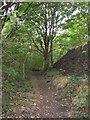
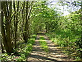
Footpath into Slead Syke Wood, Brighouse
This track was the access to extensive quarries on the crest of the hillside, to the right (north-east). These were called Clog Sole Delf (although the OS changed the spelling to 'Delph' in the late 19C).
Image: © Humphrey Bolton
Taken: 22 Sep 2007
0.07 miles
7
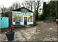
The Ironing Rooms, Kershaw's Garden Centre, Hove Edge, Brighouse
This is the last of the shops around the garden centre car park before the one way system hairpins round to the right.
Image: © Humphrey Bolton
Taken: 2 Dec 2021
0.09 miles
8
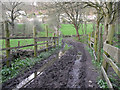
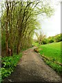
Wet Shod Lane, Hove Edge, Brighouse
There is a narrow strip to walk along next to the fence on the right.
Image: © Humphrey Bolton
Taken: 23 Mar 2020
0.09 miles
9
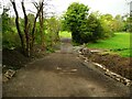
West Shod Lane crossing over Red Beck, Brighouse
This has been a very wet, see Image], but with a new surface of rolled broken stone it is now perfectly dry. The improved roadway leads to the field ahead, where a barn is to be built. A wall is being built on the right.
Image: © Humphrey Bolton
Taken: 2 May 2022
0.09 miles
10
Wetshod Lane, Brighouse
This is the dry part; the lane gets very wet in Southowram!
Image: © Humphrey Bolton
Taken: 28 Apr 2007
0.10 miles