IMAGES TAKEN NEAR TO
Ridgeway Close, HUDDERSFIELD, HD5 9RP
Introduction
This page details the photographs taken nearby to Ridgeway Close, HD5 9RP by members of the Geograph project.
The Geograph project started in 2005 with the aim of publishing, organising and preserving representative images for every square kilometre of Great Britain, Ireland and the Isle of Man.

There are currently over 7.5m images from over14,400 individuals and you can help contribute to the project by visiting https://www.geograph.org.uk
Image Map
Images are licensed for reuse under creativecommons.org/licenses/by-sa/2.0
Notes
- Clicking on the map will re-center to the selected point.
- The higher the marker number, the further away the image location is from the centre of the postcode.
Image Listing (46 Images Found)
Images are licensed for reuse under creativecommons.org/licenses/by-sa/2.0
Image
Details
Distance
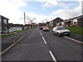
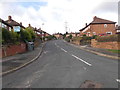
1
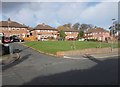
Flats along Ridgeway, Dalton
A bit of infill, built at right angles to the road.
Image: © Christine Johnstone
Taken: 20 Jan 2013
0.04 miles
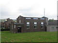
4
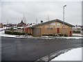
Rawthorpe & Dalton Library Information and Children's Centre
At the junction of Ridgeway and Harpe Inge.
Image: © Christine Johnstone
Taken: 20 Jan 2013
0.06 miles
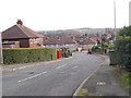
9
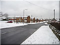
Harpe Inge, Dalton
How did this suburban road on the north side of Ridgeway get its name?
Image: © Christine Johnstone
Taken: 20 Jan 2013
0.09 miles