IMAGES TAKEN NEAR TO
Brown Royd Avenue, HUDDERSFIELD, HD5 9QA
Introduction
This page details the photographs taken nearby to Brown Royd Avenue, HD5 9QA by members of the Geograph project.
The Geograph project started in 2005 with the aim of publishing, organising and preserving representative images for every square kilometre of Great Britain, Ireland and the Isle of Man.

There are currently over 7.5m images from over14,400 individuals and you can help contribute to the project by visiting https://www.geograph.org.uk
Image Map
Images are licensed for reuse under creativecommons.org/licenses/by-sa/2.0
Notes
- Clicking on the map will re-center to the selected point.
- The higher the marker number, the further away the image location is from the centre of the postcode.
Image Listing (45 Images Found)
Images are licensed for reuse under creativecommons.org/licenses/by-sa/2.0
Image
Details
Distance
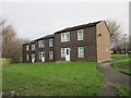
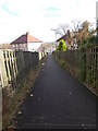
4
Nether Hall Avenue - Nether Crescent
Image: © Betty Longbottom
Taken: 16 Nov 2015
0.11 miles
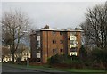
5
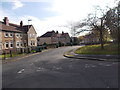
Nether Crescent - Brown Royd Avenue
Image: © Betty Longbottom
Taken: 16 Nov 2015
0.12 miles
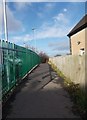
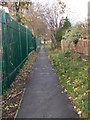
8

Entrance to Dalton Grange
The castellated gate piers are included in the grade II listing (entry 1427283) of the house itself Image The house is presently disused.
Image: © Stephen Craven
Taken: 25 Jan 2020
0.13 miles
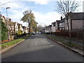
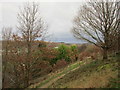
10
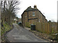
Kilner Bank, off Bradley Mills Road
This looks like a minor road but in fact used to be a through route to Moldgreen on the road to Wakefield, although the central section has now been downgraded to a footpath, perhaps to prevent rat-running.
Image: © Stephen Craven
Taken: 25 Jan 2020
0.14 miles