IMAGES TAKEN NEAR TO
Bradley Mills Road, HUDDERSFIELD, HD5 9PF
Introduction
This page details the photographs taken nearby to Bradley Mills Road, HD5 9PF by members of the Geograph project.
The Geograph project started in 2005 with the aim of publishing, organising and preserving representative images for every square kilometre of Great Britain, Ireland and the Isle of Man.

There are currently over 7.5m images from over14,400 individuals and you can help contribute to the project by visiting https://www.geograph.org.uk
Image Map
Images are licensed for reuse under creativecommons.org/licenses/by-sa/2.0
Notes
- Clicking on the map will re-center to the selected point.
- The higher the marker number, the further away the image location is from the centre of the postcode.
Image Listing (42 Images Found)
Images are licensed for reuse under creativecommons.org/licenses/by-sa/2.0
Image
Details
Distance
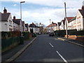
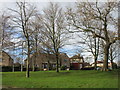
1
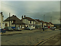
Houses and shops on Bradley Mills Road, Rawthorpe
Also a bus shelter.
Image: © Stephen Craven
Taken: 25 Jan 2020
0.02 miles
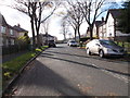
2
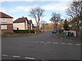
Rawthorpe Crescent - Nether Hall Avenue
Image: © Betty Longbottom
Taken: 16 Nov 2015
0.04 miles
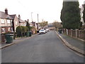
3
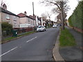
Nether Hall Avenue - Bradley Mills Road
Image: © Betty Longbottom
Taken: 16 Nov 2015
0.05 miles
5
Rawthorpe Crescent - Nether Hall Avenue
Image: © Betty Longbottom
Taken: 16 Nov 2015
0.05 miles
7
Foxlow Avenue - Rawthorpe Crescent
Image: © Betty Longbottom
Taken: 16 Nov 2015
0.09 miles
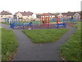
9
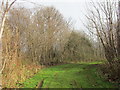
Private woodland off Bradley Mills Road
Image: © Jonathan Thacker
Taken: 14 Jan 2016
0.09 miles