IMAGES TAKEN NEAR TO
Kaye Lane, HUDDERSFIELD, HD5 8XP
Introduction
This page details the photographs taken nearby to Kaye Lane, HD5 8XP by members of the Geograph project.
The Geograph project started in 2005 with the aim of publishing, organising and preserving representative images for every square kilometre of Great Britain, Ireland and the Isle of Man.

There are currently over 7.5m images from over14,400 individuals and you can help contribute to the project by visiting https://www.geograph.org.uk
Image Map
Images are licensed for reuse under creativecommons.org/licenses/by-sa/2.0
Notes
- Clicking on the map will re-center to the selected point.
- The higher the marker number, the further away the image location is from the centre of the postcode.
Image Listing (46 Images Found)
Images are licensed for reuse under creativecommons.org/licenses/by-sa/2.0
Image
Details
Distance
1
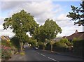
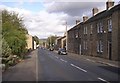
Kaye Lane, Almondbury
The road drops down to the village, where it becomes Westgate. There is ribbon development each side, and the trees were perhaps planted at around the time that the houses were built.
Image: © Humphrey Bolton
Taken: 14 Sep 2007
0.02 miles
2
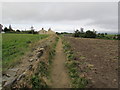
Footpath near Broken Cross, Almondbury
Heading west on footpath leading from Almondbury to Broken Cross.
Image: © Samantha Waddington
Taken: 21 Sep 2013
0.07 miles
3
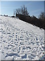
Broken Cross, Almondbury
Looking towards the snow-blocked footpath at Broken Cross.
Image: © Samantha Waddington
Taken: 31 Mar 2013
0.10 miles
4
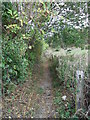
Footpath, Broken Cross, Almondbury
Looking along the footpath leading from Broken Cross towards Penny Spring Wood.
Image: © Samantha Waddington
Taken: 4 Oct 2011
0.12 miles
5
Westgate, Almondbury
There was a chapel on the north side of Westgate, and I think that the site is marked by the garden on the left.
Image: © Humphrey Bolton
Taken: 14 Sep 2007
0.12 miles
6
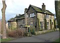
House at Broken Cross, Kaye Lane, Almondbury
The road curves round to the top of the hill, where a lane goes off to the left into the little hamlet of Broken Cross.
Image: © Humphrey Bolton
Taken: 14 Sep 2007
0.16 miles
7
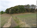
Benholmley Hill Wood, Almondbury
Looking along a field path to the southern edge of this small wood.
Image: © Samantha Waddington
Taken: 4 Oct 2011
0.16 miles
8
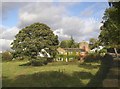
Old Clergy House, Stocks Walk, Almondbury
Built in 1898, in Arts and Crafts style; one of Edgar Wood's designs, the only one of his in Huddersfield outside the Lindley area. The buttresses are probably decorative. Divided into three homes, although it was built for four curates with dining room, kitchen and a small lecture room.
Image: © Humphrey Bolton
Taken: 19 Mar 2008
0.16 miles
9
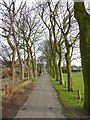
Avenue of trees, Almondbury
Along the bottom side of the recreation ground off Stocks Walk.
Image: © Humphrey Bolton
Taken: 19 Mar 2008
0.16 miles
10
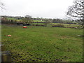
Farmland, Kaye Lane
Farmland adjacent to Kaye Lane near Broken Cross. Local sports club away in the distance.
Image: © Samantha Waddington
Taken: 3 Feb 2013
0.16 miles