IMAGES TAKEN NEAR TO
Thorpe Lane, HUDDERSFIELD, HD5 8TN
Introduction
This page details the photographs taken nearby to Thorpe Lane, HD5 8TN by members of the Geograph project.
The Geograph project started in 2005 with the aim of publishing, organising and preserving representative images for every square kilometre of Great Britain, Ireland and the Isle of Man.

There are currently over 7.5m images from over14,400 individuals and you can help contribute to the project by visiting https://www.geograph.org.uk
Image Map
Images are licensed for reuse under creativecommons.org/licenses/by-sa/2.0
Notes
- Clicking on the map will re-center to the selected point.
- The higher the marker number, the further away the image location is from the centre of the postcode.
Image Listing (64 Images Found)
Images are licensed for reuse under creativecommons.org/licenses/by-sa/2.0
Image
Details
Distance
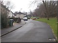
3
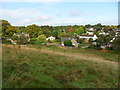
Housing and fields, eastern Almondbury.
Looking from field path to Southfield Road / Fleminghouse Lane. Fernside Park can be seen in the distance.
Image: © Samantha Waddington
Taken: 18 Sep 2011
0.07 miles
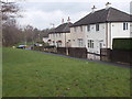
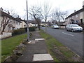
5
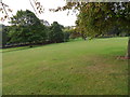
Fernside Park
Looking down the park towards Southfield Road.
Image: © Samantha Waddington
Taken: 18 Sep 2011
0.07 miles
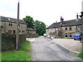
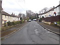
6
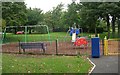
Playground - Fernside Park - Southfield Road
Image: © Betty Longbottom
Taken: 16 Sep 2008
0.08 miles