IMAGES TAKEN NEAR TO
Green Mount Close, HUDDERSFIELD, HD5 8AT
Introduction
This page details the photographs taken nearby to Green Mount Close, HD5 8AT by members of the Geograph project.
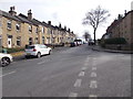
The Geograph project started in 2005 with the aim of publishing, organising and preserving representative images for every square kilometre of Great Britain, Ireland and the Isle of Man.

There are currently over 7.5m images from over14,400 individuals and you can help contribute to the project by visiting https://www.geograph.org.uk
Image Map
Images are licensed for reuse under creativecommons.org/licenses/by-sa/2.0
Notes
- Clicking on the map will re-center to the selected point.
- The higher the marker number, the further away the image location is from the centre of the postcode.
Image Listing (125 Images Found)
Images are licensed for reuse under creativecommons.org/licenses/by-sa/2.0
Image
Details
Distance
1
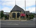
St Paul's Methodist Church - Wakefield Road
Image: © Betty Longbottom
Taken: 19 Jul 2008
0.03 miles
2
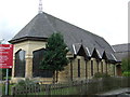
St Paul's Methodist Church
On Wakefield Road.
Image: © JThomas
Taken: 3 Oct 2014
0.03 miles
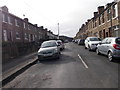
4
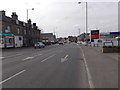
Wakefield Road - viewed from Lister Street
Image: © Betty Longbottom
Taken: 29 Feb 2016
0.04 miles
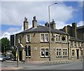
8
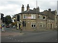
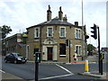
Huddersfield, the ivy green
Corner local at the junction of Wakefield Road and Broad Lane. Internally, bar to the rear left, drinking areas to the front. No cask ale available.
Image: © Mike Faherty
Taken: 17 Oct 2009
0.05 miles