IMAGES TAKEN NEAR TO
Bog Green Lane, HUDDERSFIELD, HD5 0RF
Introduction
This page details the photographs taken nearby to Bog Green Lane, HD5 0RF by members of the Geograph project.
The Geograph project started in 2005 with the aim of publishing, organising and preserving representative images for every square kilometre of Great Britain, Ireland and the Isle of Man.

There are currently over 7.5m images from over14,400 individuals and you can help contribute to the project by visiting https://www.geograph.org.uk
Image Map
Images are licensed for reuse under creativecommons.org/licenses/by-sa/2.0
Notes
- Clicking on the map will re-center to the selected point.
- The higher the marker number, the further away the image location is from the centre of the postcode.
Image Listing (63 Images Found)
Images are licensed for reuse under creativecommons.org/licenses/by-sa/2.0
Image
Details
Distance
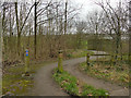
1
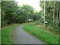
The Calder Valley Greenway, Kirkheaton
This is along a disused railway line which was in cutting here. The line was purchased for use as a tip, and there are large vent pipes, with green conical hats, at intervals to allow methane and other gases generated underground to escape.
Image: © Humphrey Bolton
Taken: 11 Sep 2008
0.05 miles
3
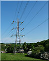
A pylon seen from The Calder Valley Greenway between Bog Green Lane and Dalton Bank Road, Huddersfield
Image: © habiloid
Taken: 24 May 2023
0.05 miles
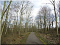
4
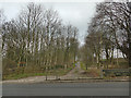
Calder Valley Greenway, east from Bog Green Lane
This section of National Cycle Route 66 follows the line of the former Lancashire & Yorkshire Railway goods line to its depot in Huddersfield, closed certainly by the 1960s if not earlier. It is now part of the Calder Valley Greenway.
Image: © Stephen Craven
Taken: 25 Jan 2020
0.05 miles
5
Calder Valley Greenway, west from Bog Green Lane
This section of National Cycle Route 66 follows the line of the former Lancashire & Yorkshire Railway goods line to its depot in Huddersfield, closed certainly by the 1960s if not earlier. It has been part of the Calder Valley Greenway since c.2006, see Image
Image: © Stephen Craven
Taken: 25 Jan 2020
0.05 miles
6
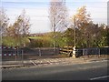
An entrance to The Calder Valley Greenway, Bog Green Lane (B6118), Huddersfield
Image: © habiloid
Taken: 24 May 2023
0.05 miles

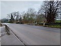
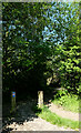
9
National Cycle Route 69
Towards Mirfield on a disused railway track bed.
Image: © JThomas
Taken: 6 Mar 2020
0.07 miles
10
Entrance to the Calder Valley Greenway under construction westwards from Bog Green Lane, Kirkheaton
This section will descend into the Colne Valley, pass under Dalton Bank Road and go over the disused railway viaduct over the river and the canal.
Image: © Humphrey Bolton
Taken: 18 Nov 2006
0.08 miles