1
Cooper Bridge Floodgates
Looking eastwards (downstream). Boats heading for Wakefield keep left here through the (usually open) floodgates. Those heading for Huddersfield stay on the right, in the weir stream, until the entrance lock to the Huddersfield Broad Canal is seen on the right. There used to be footbridge here, whose abutment on the north bank can be seen just to the left of the floodgates. The absence of this bridge makes things somewhat difficult for walkers.
Image: © Dr Neil Clifton
Taken: 5 May 2008
0.01 miles
2
Cooper Bridge Flood lock
At the western end of Cooper Bridge cut. Normally left open.
Image: © Dr Neil Clifton
Taken: 25 Jul 1996
0.01 miles
3
Cooper Bridge Flood Lock, Calder and Hebble Canal
There is a junction here, as the sign indicates. Right leads to the Huddersfield Broad Canal, while straight on through the floodgates (normally left open) leads to Wakefield.
Image: © Dr Neil Clifton
Taken: 16 Jun 2001
0.01 miles
4
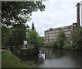
Feamley's Mill
View looking up the River Calder to Feamley's Mill.
Image: © Peter McDermott
Taken: 6 Jan 2013
0.01 miles
5
Holme Mills, Bradley, Huddersfield
Now converted to accommodation. It is on Fearnley Mill Drive but various sources give its proper name as Holme Mills.
Image: © Chris Allen
Taken: 5 May 2023
0.01 miles
6
Holme Mills, Bradley, Huddersfield
Now converted to accommodation. It is on Fearnley Mill Drive but various sources give its proper name as Holme Mills.
Image: © Chris Allen
Taken: 5 May 2023
0.02 miles
7
Fearnley Mill, Bradley
Fearnley Mill is seen across the Calder from Cooper Bridge.
Image: © habiloid
Taken: 14 Apr 2020
0.02 miles
8
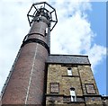
Above us only the sky!
Standing on Lower Quarry Road in Bradley, I took this upshot view of the stone stair tower and its loftier red brick chimney companion at Fearnley's Mill. The chimney is now a ready made comms tower. The water tank resting on top of the stair tower was fabricated by Witter & Son of Bolton.
The attached buildings are located between Lower Quarry Road and Fearnley Mill Drive in Bradley.
Image: © Bobby Clegg
Taken: 17 Aug 2015
0.02 miles
9
Calder and Hebble Navigation
Sign on the Calder and Hebble Navigation Canal.
Image: © Peter McDermott
Taken: 6 Jan 2013
0.03 miles
10
River Calder at Cooper Bridge Flood Gate
The Calder and Hebble Navigation leaves the river through the flood gate on the left.
Image: © habiloid
Taken: 6 Jul 2019
0.03 miles


