IMAGES TAKEN NEAR TO
Jagger Lane, HUDDERSFIELD, HD5 0QY
Introduction
This page details the photographs taken nearby to Jagger Lane, HD5 0QY by members of the Geograph project.
The Geograph project started in 2005 with the aim of publishing, organising and preserving representative images for every square kilometre of Great Britain, Ireland and the Isle of Man.

There are currently over 7.5m images from over14,400 individuals and you can help contribute to the project by visiting https://www.geograph.org.uk
Image Map
Images are licensed for reuse under creativecommons.org/licenses/by-sa/2.0
Notes
- Clicking on the map will re-center to the selected point.
- The higher the marker number, the further away the image location is from the centre of the postcode.
Image Listing (20 Images Found)
Images are licensed for reuse under creativecommons.org/licenses/by-sa/2.0
Image
Details
Distance
1
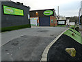
Yorkshire Artificial Lawns, Nettleton Road
The greenery here (and the black stuff in the foreground) are examples of their products.
Image: © Stephen Craven
Taken: 25 Jan 2020
0.02 miles
2
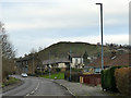
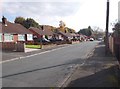
Nab Hill, Dalton
'Nab' in West Riding dialect means a small hill or promontory like this, so 'hill' is a redundant addition.
Image: © Stephen Craven
Taken: 25 Jan 2020
0.11 miles
3
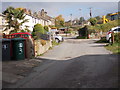
Nettleton Terrace - Nettleton Road
Image: © Betty Longbottom
Taken: 26 Oct 2015
0.13 miles
4
Location of Batley CWW air valve marker plate
See Image for a close view of the plate.
Image: © Humphrey Bolton
Taken: 27 Jul 2013
0.14 miles
5
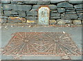
Batley Corporation Water Works air valve marker plate
Batley's reservoirs were constructed in the upper Holme Valley, and a long supply main was required. This plate is dated 1928.
Image: © Humphrey Bolton
Taken: 27 Jul 2013
0.15 miles
6
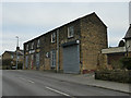
Workshop on Nettleton Road
Most recently occupied by Plasticraft Displays Ltd, currently vacant.
Image: © Stephen Craven
Taken: 25 Jan 2020
0.15 miles
7
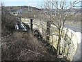
Railway bridge, Dalton Bank Road, Dalton
This was over the Kirkburton branch line. There is a pipe bridge on the left.
Image: © Humphrey Bolton
Taken: 9 Mar 2010
0.18 miles
8
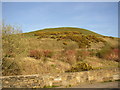
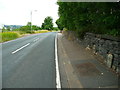
Nab Hill, Dalton
View from Dalton Bank Road. Nab Hill is a steep-sided promontory jutting out from Dalton Bank.
Image: © Humphrey Bolton
Taken: 5 Apr 2007
0.18 miles
10
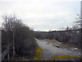
The view South from the Footbridge below Dalton Bank
Image: © Michael Steele
Taken: 19 Jan 2015
0.20 miles