IMAGES TAKEN NEAR TO
Shop Lane, HUDDERSFIELD, HD5 0DD
Introduction
This page details the photographs taken nearby to Shop Lane, HD5 0DD by members of the Geograph project.
The Geograph project started in 2005 with the aim of publishing, organising and preserving representative images for every square kilometre of Great Britain, Ireland and the Isle of Man.

There are currently over 7.5m images from over14,400 individuals and you can help contribute to the project by visiting https://www.geograph.org.uk
Image Map
Images are licensed for reuse under creativecommons.org/licenses/by-sa/2.0
Notes
- Clicking on the map will re-center to the selected point.
- The higher the marker number, the further away the image location is from the centre of the postcode.
Image Listing (100 Images Found)
Images are licensed for reuse under creativecommons.org/licenses/by-sa/2.0
Image
Details
Distance
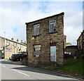
5
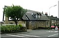
Kirkheaton Conservative Club - Heaton Moor Road
Image: © Betty Longbottom
Taken: 19 Jul 2008
0.04 miles
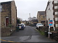
6
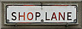
The Shop Lane street name sign, Kirkheaton
This sign can be seen in context in Image
Image: © habiloid
Taken: 29 Sep 2023
0.04 miles
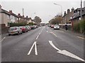
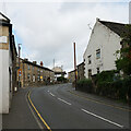
9
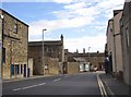
Shop Lane, Kirkheaton
The winding main road up to the village. There is a stone-built single-storey shop near to the bend (however the road name probably refers to a workshop).
Image: © Humphrey Bolton
Taken: 14 Sep 2007
0.05 miles
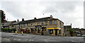
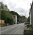
10
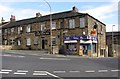
'The Junction' and corner shop
The junction after which the pub was named is the cross-roads in the centre of the village.
Image: © Humphrey Bolton
Taken: 14 Sep 2007
0.05 miles