IMAGES TAKEN NEAR TO
Hangingstone Road, HUDDERSFIELD, HD4 7QS
Introduction
This page details the photographs taken nearby to Hangingstone Road, HD4 7QS by members of the Geograph project.
The Geograph project started in 2005 with the aim of publishing, organising and preserving representative images for every square kilometre of Great Britain, Ireland and the Isle of Man.

There are currently over 7.5m images from over14,400 individuals and you can help contribute to the project by visiting https://www.geograph.org.uk
Image Map
Images are licensed for reuse under creativecommons.org/licenses/by-sa/2.0
Notes
- Clicking on the map will re-center to the selected point.
- The higher the marker number, the further away the image location is from the centre of the postcode.
Image Listing (11 Images Found)
Images are licensed for reuse under creativecommons.org/licenses/by-sa/2.0
Image
Details
Distance
1
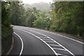
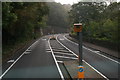
A616 to Holmfirth running past Park Wood
Holme Valley on the right.
Image: © Chris
Taken: 11 Sep 2014
0.12 miles
3
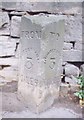
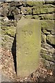
Old Milestone by the A616, Woodhead Road, Huddersfield
Carved stone post by the A616, in parish of HUDDERSFIELD (KIRKLEES District), beneath Parkwood, Woodhead Road; opposite Lamppost 105, back to wall on bike route painted on carriageway, on North side of road. Hudds 'To - From' stone, erected by the Wadsley & Langsett turnpike trust in the 19th century.
Inscription reads:-
: FROM / HUDDERSFIELD / 3 MILES : : TO / HUDDERSFIELD / 3 MILES :
Milestone Society National ID: YW_XHTF12.
Image: © C Minto
Taken: 1 Sep 2001
0.18 miles
4
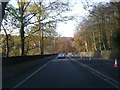
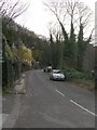
Double-decker houses, Woodhead Road, Berry Brow, Almondbury
The bottom houses are back-to-earth, the top ones face onto Robin Hood Hill behind. The road signs show how Kirklees Council are keen to encourage cycling. Where there is no longer enough road width for a cycle lane the timid are allowed to use the footway, although it is rather narrow, and motorists are asked to give space to cyclists staying on the road.
Image: © Humphrey Bolton
Taken: 12 Oct 2006
0.19 miles
5
Milestone, Woodhead Road, Berry Brow, Almondbury
This is one of a series on all the main roads out of Huddersfield, giving distances to and from the town centre and possibly to do with tram fare stages (?). There is another one half-a-mile towards Honley.
Image: © Humphrey Bolton
Taken: 5 Apr 2007
0.19 miles
6

Old Milestone by the A616, Woodhead Road, Armitage Bridge
Carved stone post by the A616, in parish of HUDDERSFIELD (KIRKLEES District), Woodhead Road, S of Berry Brow, against wall, 1m wide cycle route marked on tarmac of carriageway, on East side of road. Huddersfield 'To - From' stone, erected by the Wadsley & Langsett turnpike trust in the 19th century.
Inscription reads:-
: FROM / HUDDERSFIELD / 2½ / MILES : : TO / HUDDERSFIELD / 2½ / MILES :
Milestone Society National ID: YW_XHTF11.
Image: © C Minto
Taken: 1 Sep 2001
0.19 miles
8
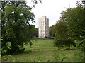
Holme Park Court, Berry Brow, Almondbury
One of two tower blocks of flats next to the countryside and near to a main road.
Image: © Humphrey Bolton
Taken: 12 Oct 2006
0.22 miles
10
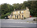
The Golden Fleece, Berry Brow, Almondbury
This old inn was probably there when traffic used Robin Hood Hill, the road on the far right, before Woodhead Road, in the foreground, was constructed c.1830.
Image: © Humphrey Bolton
Taken: 12 Oct 2006
0.25 miles