IMAGES TAKEN NEAR TO
Windmill Terrace, HUDDERSFIELD, HD4 7QL
Introduction
This page details the photographs taken nearby to Windmill Terrace, HD4 7QL by members of the Geograph project.
The Geograph project started in 2005 with the aim of publishing, organising and preserving representative images for every square kilometre of Great Britain, Ireland and the Isle of Man.

There are currently over 7.5m images from over14,400 individuals and you can help contribute to the project by visiting https://www.geograph.org.uk
Image Map
Images are licensed for reuse under creativecommons.org/licenses/by-sa/2.0
Notes
- Clicking on the map will re-center to the selected point.
- The higher the marker number, the further away the image location is from the centre of the postcode.
Image Listing (95 Images Found)
Images are licensed for reuse under creativecommons.org/licenses/by-sa/2.0
Image
Details
Distance
1
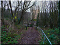
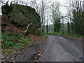
Stoney Lane, Berry Brow, Huddersfield
Here the old road, which was probably no better than a packhorse track, descends steeply to the Fleece Inn, where there was a smithy.
Image: © Humphrey Bolton
Taken: 10 Dec 2020
0.03 miles
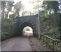
3
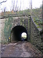
Bridge PEH-17 - off Robin Hood Hill
Image: © Betty Longbottom
Taken: 10 Nov 2010
0.05 miles
4
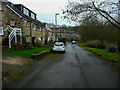
Houses along Deadmanstone, Berry Brow, Huddersfield
This was the original road up the valley before the present road was constructed by a turnpike trust in 1810 or later.
Image: © Humphrey Bolton
Taken: 10 Dec 2020
0.05 miles
6
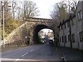
Bridge Street, Berry Brow, Almondbury
The railway is the scenic line from Huddersfield to Penistone and Sheffield. Much of the old property in Berry Brow was demolished (in the 60s?) and the houses on the right are recent replacements.
Image: © Humphrey Bolton
Taken: 29 Nov 2005
0.06 miles
8
The rock on Deadmanstone, Berry Brow
Was the road, and the house with the same name that was demolished in 1968, named after this rock? There was a Wesleyan chapel built in 1824 behind the camera on the left.
Image: © Humphrey Bolton
Taken: 10 Dec 2020
0.08 miles
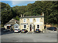
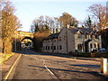
9
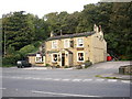
The Golden Fleece, Berry Brow, Almondbury
This old inn was probably there when traffic used Robin Hood Hill, the road on the far right, before Woodhead Road, in the foreground, was constructed c.1830.
Image: © Humphrey Bolton
Taken: 12 Oct 2006
0.09 miles
