IMAGES TAKEN NEAR TO
Chapel Close, HUDDERSFIELD, HD4 7QH
Introduction
This page details the photographs taken nearby to Chapel Close, HD4 7QH by members of the Geograph project.
The Geograph project started in 2005 with the aim of publishing, organising and preserving representative images for every square kilometre of Great Britain, Ireland and the Isle of Man.

There are currently over 7.5m images from over14,400 individuals and you can help contribute to the project by visiting https://www.geograph.org.uk
Image Map
Images are licensed for reuse under creativecommons.org/licenses/by-sa/2.0
Notes
- Clicking on the map will re-center to the selected point.
- The higher the marker number, the further away the image location is from the centre of the postcode.
Image Listing (156 Images Found)
Images are licensed for reuse under creativecommons.org/licenses/by-sa/2.0
Image
Details
Distance
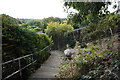
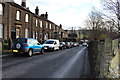
4
School Lane - viewed from Waingate
Image: © Betty Longbottom
Taken: 10 Nov 2010
0.04 miles
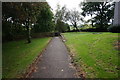
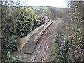
8
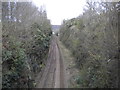
Railway line north west of Berry Brow station
Looking towards Huddersfield. Berry Brow railway station is the other side of the bridge on which the photographer is standing.
Image: © Richard Vince
Taken: 10 Apr 2019
0.05 miles
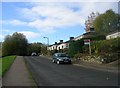
10
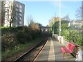
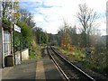
Berry Brow railway station
Looking towards Penistone and Barnsley.
Image: © Richard Vince
Taken: 10 Apr 2019
0.05 miles