IMAGES TAKEN NEAR TO
Stockwell Hill, HUDDERSFIELD, HD4 7NL
Introduction
This page details the photographs taken nearby to Stockwell Hill, HD4 7NL by members of the Geograph project.
The Geograph project started in 2005 with the aim of publishing, organising and preserving representative images for every square kilometre of Great Britain, Ireland and the Isle of Man.

There are currently over 7.5m images from over14,400 individuals and you can help contribute to the project by visiting https://www.geograph.org.uk
Image Map
Images are licensed for reuse under creativecommons.org/licenses/by-sa/2.0
Notes
- Clicking on the map will re-center to the selected point.
- The higher the marker number, the further away the image location is from the centre of the postcode.
Image Listing (157 Images Found)
Images are licensed for reuse under creativecommons.org/licenses/by-sa/2.0
Image
Details
Distance
2
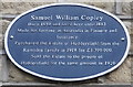
Samuel William Copley
Blue plaque on Barry Brow Liberal Club.
Image: © Ian S
Taken: 5 Oct 2016
0.01 miles
3
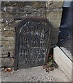
Batley CWW
18" Main, Hyd Scoup, 11ft Rad, 1928. Old water sign on Stockwell Hill, Armitage Bridge.
Image: © Ian S
Taken: 5 Oct 2016
0.01 miles
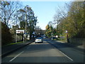
4
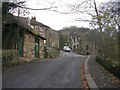
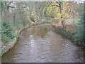
Stockwell Hill - viewed from Armitage Road
Image: © Betty Longbottom
Taken: 10 Nov 2010
0.01 miles