IMAGES TAKEN NEAR TO
Fare Hill Flats, HUDDERSFIELD, HD4 7LU
Introduction
This page details the photographs taken nearby to Fare Hill Flats, HD4 7LU by members of the Geograph project.
The Geograph project started in 2005 with the aim of publishing, organising and preserving representative images for every square kilometre of Great Britain, Ireland and the Isle of Man.

There are currently over 7.5m images from over14,400 individuals and you can help contribute to the project by visiting https://www.geograph.org.uk
Image Map
Images are licensed for reuse under creativecommons.org/licenses/by-sa/2.0
Notes
- Clicking on the map will re-center to the selected point.
- The higher the marker number, the further away the image location is from the centre of the postcode.
Image Listing (153 Images Found)
Images are licensed for reuse under creativecommons.org/licenses/by-sa/2.0
Image
Details
Distance
1
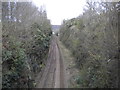
Railway line north west of Berry Brow station
Looking towards Huddersfield. Berry Brow railway station is the other side of the bridge on which the photographer is standing.
Image: © Richard Vince
Taken: 10 Apr 2019
0.03 miles
2
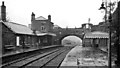
Berry Brow (former) Station
View NW, towards Huddersfield; Penistone - Huddersfield line. This station was closed 4/7/66, but rebuilt 300 yards nearer Penistone 9/10/89.
Image: © Ben Brooksbank
Taken: 22 Apr 1961
0.03 miles
9
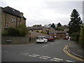
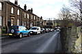
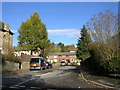
Farehill Road, Berry Brow
Seen from Birch Road.
Image: © Richard Vince
Taken: 10 Apr 2019
0.06 miles