IMAGES TAKEN NEAR TO
Sandy Lane, HUDDERSFIELD, HD4 7BX
Introduction
This page details the photographs taken nearby to Sandy Lane, HD4 7BX by members of the Geograph project.
The Geograph project started in 2005 with the aim of publishing, organising and preserving representative images for every square kilometre of Great Britain, Ireland and the Isle of Man.

There are currently over 7.5m images from over14,400 individuals and you can help contribute to the project by visiting https://www.geograph.org.uk
Image Map
Images are licensed for reuse under creativecommons.org/licenses/by-sa/2.0
Notes
- Clicking on the map will re-center to the selected point.
- The higher the marker number, the further away the image location is from the centre of the postcode.
Image Listing (16 Images Found)
Images are licensed for reuse under creativecommons.org/licenses/by-sa/2.0
Image
Details
Distance
1
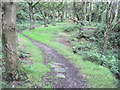
Byway to Nether Moor, South Crosland
This goes from Sandy Lane to Nether Moor Road.
NB - Update - This has been blocked at Netherton Moor Farm and you cannot get through to Nether Moor Lane. The farmer insists that the lane was included on the definitive map in error. http://www.examiner.co.uk/news/west-yorkshire-news/kirklees-council-backs-down-right-10357858
Image: © Humphrey Bolton
Taken: 19 Jul 2007
0.03 miles
2
Thannet Well, South Crosland
Water, water everywhere at present, but not a drop into this trough. This seems strange, as I would expect there to be a steady flow from an aquifer; there is a steep hillside above.
Image: © Humphrey Bolton
Taken: 10 Nov 2020
0.09 miles
4
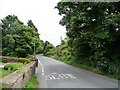
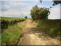
School Hill, Stony Batter
'Slow' for the descent to a sharp corner on the way to South Crosland.
Image: © Christine Johnstone
Taken: 28 Jun 2011
0.18 miles
6
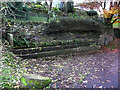
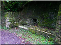
Crab Tree Well, Pinfold Green, South Crosland
Five troughs are linked in sequence by pipes. They had not been used for many years and were filled with mud and overgrown with weeds, nettles, brambles and tree roots. They were cleared and restored by the Friends of Dean Wood in 2013.
Image: © Humphrey Bolton
Taken: 10 Nov 2020
0.20 miles
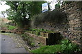
7
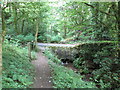
Pinfold, South Crosland
The Friends of Dean Wood worked to clear the pinfold and drinking trough in the summer of 2013.
Image: © Humphrey Bolton
Taken: 10 Nov 2020
0.20 miles
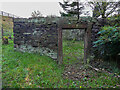
8
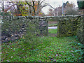
Interior of the pinfold, South Crosland
This pinfold was cleared and restored by the Friends of Dean Wood in 2013.
Image: © Humphrey Bolton
Taken: 10 Nov 2020
0.20 miles
9
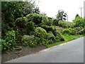
'Front gardens', Stony Batter [1]
Actually on the opposite side of the road to the houses.
Image: © Christine Johnstone
Taken: 28 Jun 2011
0.21 miles